Broye geodata
Broye (Bourgogne-Franche-Comté) is a populated place; located in France in Europe/Paris (GMT+2) time zone. With population of 695 people, there are 11873 cities with bigger population in this country. Compared to other cities in France, 56.5% of cities are located further ↑North; 70.5% of cities are located further ←West and 81.9% of cities have lower elevation than Broye. Note1
Administrative division(s):
- Level 1: Bourgogne-Franche-Comté
- Level 2: Département de Saône-et-Loire
- Level 3: Autun
- Level 4: Broye


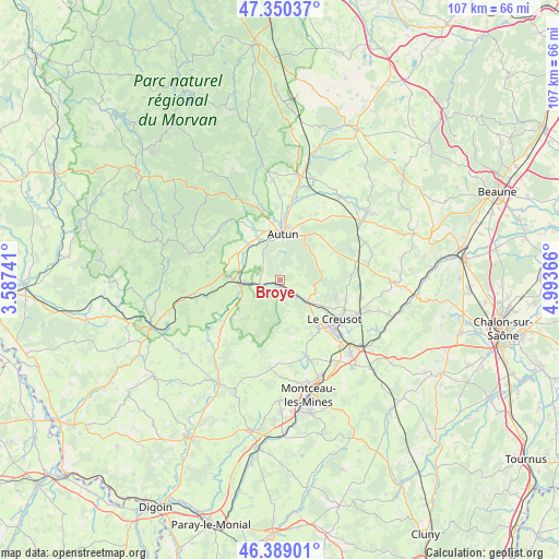
Broye GPS coordinates[2]
46° 52' 18.624" North, 4° 17' 25.944" East
| Map corner | latitude | longitude |
|---|---|---|
| Upper-left | 47.35037°, | 3.58741° |
| Center: | 46.87184°, | 4.29054° |
| Lower-right: | 46.38901°, | 4.99366° |
| Map W x H: | 106.9×106.9 km | = 66.4×66.4mi |
| max Lat: | 51.07786° ⇑56.5% North |
| Broye: | 46.87184° |
| min Lat: | ⇓43.5% South 41.3874° |
| min Long | Broye | max Long |
| -5.08615° | 4.29054° | 9.52242° |
| W 70.5%⇐ | ⇒29.5% E |
Elevation
Elevation of Broye is 310 m = 1017 ft, and this is 116.3 m = 382 ft above average elevation for this country.
| Max E: |
2333 m = 7654 ft | 18.1% |
| Broye | 310 m 1017 ft | |
| Avg. | 193.7 m = 635 ft | |
Min E: |
-1 m = -3 ft | 81.9% |
See also: France elevation on elevation.city.
Geographical zone
Broye is located in North temperate zone (between Tropic of Cancer and the Arctic Circle). Distance of this North polar circle is 2189.5 km =1360.5 mi to North.| Distance of | km | miles | from Broye |
|---|---|---|---|
| North Pole | 4795.4 | 2979.7 | to North |
| Arctic Circle | 2189.5 | 1360.5 | to North |
| Tropic Cancer | 2605.7 | 1619.1 | to South |
| Equator | 5211.7 | 3238.4 | to South |


Nearby cities:
15 places around Broye: (largest is in red/bold)
• Antully
9.8 km =6.1 mi,  68°
68°
• Autun
8.8 km =5.5 mi,  4°
4°
• Auxy
12.2 km =7.6 mi,  45°
45°
• Curgy
14.7 km =9.1 mi,  29°
29°
• Laizy
8 km =5 mi,  299°
299°
• Le Breuil
15.4 km =9.6 mi,  118°
118°
• Le Creusot
12 km =7.5 mi,  126°
126°
• Marmagne
6.5 km =4 mi, 126°
• Mesvres
3.8 km =2.4 mi,  256°
256°
• Montcenis
11.9 km =7.4 mi,  141°
141°
• Saint-Firmin
14.4 km =8.9 mi,  109°
109°
• Saint-Forgeot
14.7 km =9.1 mi, 2°
• Saint-Sernin-du-Bois
11.3 km =7 mi, 107°
• Saint-Symphorien-de-Marmagne
4.8 km =3 mi, 139°
• Étang-sur-Arroux
7.7 km =4.8 mi, 264°
Sources, notices
• [Note1] Compared only with cities in France existing in our database
• [Src1] Map data: © OpenStreetMap contributors (CC-BY-SA)
• [Src2] Other city data from geonames.org with taken over terms of usage.
• [Src3] Geographical zone / Annual Mean Temperature by Robert A. Rohde @ Wikipedia
