Manigod geodata
Manigod (Auvergne-Rhône-Alpes) is a populated place; located in France in Europe/Paris (GMT+2) time zone. With population of 866 people, there are 9930 cities with bigger population in this country. Compared to other cities in France, 68.3% of cities are located further ↑North; 90.9% of cities are located further ←West and 99.3% of cities have lower elevation than Manigod. Note1
Administrative division(s):
- Level 1: Auvergne-Rhône-Alpes
- Level 2: Haute-Savoie
- Level 3: Annecy
- Level 4: Manigod


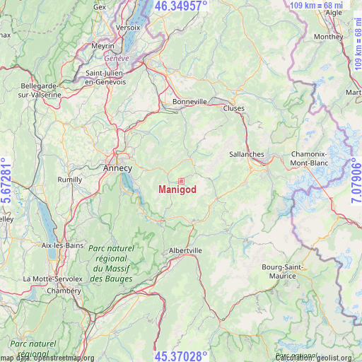
Manigod GPS coordinates[2]
45° 51' 43.488" North, 6° 22' 33.384" East
| Map corner | latitude | longitude |
|---|---|---|
| Upper-left | 46.34957°, | 5.67281° |
| Center: | 45.86208°, | 6.37594° |
| Lower-right: | 45.37028°, | 7.07906° |
| Map W x H: | 108.9×108.9 km | = 67.7×67.7mi |
| max Lat: | 51.07786° ⇑68.3% North |
| Manigod: | 45.86208° |
| min Lat: | ⇓31.7% South 41.3874° |
| min Long | Manigod | max Long |
| -5.08615° | 6.37594° | 9.52242° |
| W 90.9%⇐ | ⇒9.1% E |
Elevation
Elevation of Manigod is 1049 m = 3442 ft, and this is 855.3 m = 2806 ft above average elevation for this country.
| Max E: |
2333 m = 7654 ft | 0.7% |
| Manigod | 1049 m 3442 ft | |
| Avg. | 193.7 m = 635 ft | |
Min E: |
-1 m = -3 ft | 99.3% |
See also: France elevation on elevation.city.
Geographical zone
Manigod is located in North temperate zone (between Tropic of Cancer and the Arctic Circle). Distance of this North polar circle is 2301.8 km =1430.3 mi to North.| Distance of | km | miles | from Manigod |
|---|---|---|---|
| North Pole | 4907.7 | 3049.5 | to North |
| Arctic Circle | 2301.8 | 1430.3 | to North |
| Tropic Cancer | 2493.5 | 1549.4 | to South |
| Equator | 5099.4 | 3168.6 | to South |


Nearby cities:
15 places around Manigod: (largest is in red/bold)
• Alex
11.3 km =7 mi,  286°
286°
• Entremont
10.5 km =6.5 mi,  5°
5°
• Flumet
11.8 km =7.3 mi,  114°
114°
• La Clusaz
6.7 km =4.2 mi,  42°
42°
• La Giettaz
9.2 km =5.7 mi,  88°
88°
• Le Grand-Bornand
9.9 km =6.2 mi,  25°
25°
• Les Clefs
3.6 km =2.2 mi,  268°
268°
• Les Villards-sur-Thônes
5.8 km =3.6 mi,  359°
359°
• Marlens
11 km =6.8 mi,  192°
192°
• Notre-Dame-de-Bellecombe
12.5 km =7.8 mi,  118°
118°
• Saint-Ferréol
12.1 km =7.5 mi,  205°
205°
• Saint-Jean-de-Sixt
7.3 km =4.5 mi,  22°
22°
• Serraval
7.3 km =4.5 mi,  202°
202°
• Thônes
4.4 km =2.7 mi,  298°
298°
• Ugine
12.2 km =7.6 mi,  165°
165°
Sources, notices
• [Note1] Compared only with cities in France existing in our database
• [Src1] Map data: © OpenStreetMap contributors (CC-BY-SA)
• [Src2] Other city data from geonames.org with taken over terms of usage.
• [Src3] Geographical zone / Annual Mean Temperature by Robert A. Rohde @ Wikipedia
