Marcilly-sur-Vienne geodata
Marcilly-sur-Vienne (Centre) is a populated place; located in France in Europe/Paris (GMT+2) time zone. With population of 529 people, there are 14624 cities with bigger population in this country. Compared to other cities in France, 54.9% of cities are located further ↑North; 73% of cities are located further →East and 84.5% of cities have higher elevation than Marcilly-sur-Vienne. Note1
Administrative division(s):
- Level 1: Centre
- Level 2: Département d'Indre-et-Loire
- Level 3: Arrondissement de Chinon
- Level 4: Marcilly-sur-Vienne


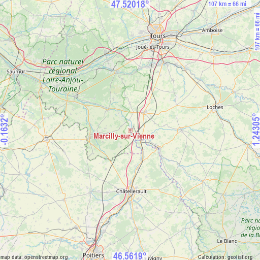
Marcilly-sur-Vienne GPS coordinates[2]
47° 2' 35.484" North, 0° 32' 23.748" East
| Map corner | latitude | longitude |
|---|---|---|
| Upper-left | 47.52018°, | -0.1632° |
| Center: | 47.04319°, | 0.53993° |
| Lower-right: | 46.5619°, | 1.24305° |
| Map W x H: | 106.6×106.5 km | = 66.2×66.2mi |
| max Lat: | 51.07786° ⇑54.9% North |
| Marcilly-sur-Vienne: | 47.04319° |
| min Lat: | ⇓45.1% South 41.3874° |
| min Long | Marcilly-sur-Vi | max Long |
| -5.08615° | 0.53993° | 9.52242° |
| W 27%⇐ | ⇒73% E |
Elevation
Elevation of Marcilly-sur-Vienne is 43 m = 141 ft, and this is 150.7 m = 494 ft below average elevation for this country.
| Max E: |
2333 m = 7654 ft | 84.5% |
| Avg. | 193.7 m = 635 ft | |
| Marcilly-sur-Vienne | 43 m = 141 ft | |
Min E: |
-1 m = -3 ft | 15.5% |
See also: France elevation on elevation.city.
Geographical zone
Marcilly-sur-Vienne is located in North temperate zone (between Tropic of Cancer and the Arctic Circle). Distance of this North polar circle is 2170.5 km =1348.7 mi to North.| Distance of | km | miles | from Marcilly-sur-Vienne |
|---|---|---|---|
| North Pole | 4776.3 | 2967.9 | to North |
| Arctic Circle | 2170.5 | 1348.7 | to North |
| Tropic Cancer | 2624.8 | 1631 | to South |
| Equator | 5230.7 | 3250.2 | to South |


Nearby cities:
15 places around Marcilly-sur-Vienne: (largest is in red/bold)
• Crouzilles
10.8 km =6.7 mi,  325°
325°
• Draché
6.6 km =4.1 mi,  78°
78°
• L'Île-Bouchard
12.4 km =7.7 mi,  311°
311°
• La Celle-Saint-Avant
5.5 km =3.4 mi,  115°
115°
• La Tour-Saint-Gelin
10.4 km =6.5 mi,  273°
273°
• Les Ormes
9.4 km =5.8 mi,  147°
147°
• Maillé
3.4 km =2.1 mi,  69°
69°
• Marigny-Marmande
7.9 km =4.9 mi,  209°
209°
• Nouâtre
1.1 km =0.7 mi,  39°
39°
• Noyant-de-Touraine
7.6 km =4.7 mi,  11°
11°
• Parçay-sur-Vienne
8.4 km =5.2 mi, 325°
• Port-de-Piles
6.4 km =4 mi,  134°
134°
• Pouzay
4.4 km =2.7 mi,  353°
353°
• Saint-Épain
11.3 km =7 mi,  358°
358°
• Sainte-Maure-de-Touraine
9.8 km =6.1 mi, 39°
Sources, notices
• [Note1] Compared only with cities in France existing in our database
• [Src1] Map data: © OpenStreetMap contributors (CC-BY-SA)
• [Src2] Other city data from geonames.org with taken over terms of usage.
• [Src3] Geographical zone / Annual Mean Temperature by Robert A. Rohde @ Wikipedia
