Marigny-Marmande geodata
Marigny-Marmande (Centre) is a populated place; located in France in Europe/Paris (GMT+2) time zone. With population of 653 people, there are 12485 cities with bigger population in this country. Compared to other cities in France, 55.5% of cities are located further ↑North; 73.5% of cities are located further →East and 63.6% of cities have higher elevation than Marigny-Marmande. Note1
Administrative division(s):
- Level 1: Centre
- Level 2: Département d'Indre-et-Loire
- Level 3: Arrondissement de Chinon
- Level 4: Marigny-Marmande


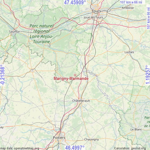
Marigny-Marmande GPS coordinates[2]
46° 58' 53.58" North, 0° 29' 21.984" East
| Map corner | latitude | longitude |
|---|---|---|
| Upper-left | 47.45909°, | -0.21368° |
| Center: | 46.98155°, | 0.48944° |
| Lower-right: | 46.4997°, | 1.19257° |
| Map W x H: | 106.7×106.7 km | = 66.3×66.3mi |
| max Lat: | 51.07786° ⇑55.5% North |
| Marigny-Marmande: | 46.98155° |
| min Lat: | ⇓44.5% South 41.3874° |
| min Long | Marigny-Marmand | max Long |
| -5.08615° | 0.48944° | 9.52242° |
| W 26.5%⇐ | ⇒73.5% E |
Elevation
Elevation of Marigny-Marmande is 93 m = 305 ft, and this is 100.7 m = 330 ft below average elevation for this country.
| Max E: |
2333 m = 7654 ft | 63.6% |
| Avg. | 193.7 m = 635 ft | |
| Marigny-Marmande | 93 m = 305 ft | |
Min E: |
-1 m = -3 ft | 36.4% |
See also: France elevation on elevation.city.
Geographical zone
Marigny-Marmande is located in North temperate zone (between Tropic of Cancer and the Arctic Circle). Distance of this North polar circle is 2177.3 km =1352.9 mi to North.| Distance of | km | miles | from Marigny-Marmande |
|---|---|---|---|
| North Pole | 4783.2 | 2972.1 | to North |
| Arctic Circle | 2177.3 | 1352.9 | to North |
| Tropic Cancer | 2617.9 | 1626.7 | to South |
| Equator | 5223.9 | 3246 | to South |


Nearby cities:
15 places around Marigny-Marmande: (largest is in red/bold)
• Chaveignes
12.3 km =7.6 mi,  300°
300°
• Dangé-Saint-Romain
10 km =6.2 mi,  122°
122°
• Draché
13.2 km =8.2 mi,  51°
51°
• La Celle-Saint-Avant
9.8 km =6.1 mi,  62°
62°
• La Tour-Saint-Gelin
10 km =6.2 mi,  319°
319°
• Les Ormes
8.9 km =5.5 mi,  96°
96°
• Maillé
10.7 km =6.6 mi,  41°
41°
• Marcilly-sur-Vienne
7.9 km =4.9 mi,  29°
29°
• Nouâtre
8.9 km =5.5 mi, 30°
• Port-de-Piles
8.7 km =5.4 mi,  74°
74°
• Pouzay
11.7 km =7.3 mi,  16°
16°
• Richelieu
13 km =8.1 mi,  285°
285°
• Saint-Gervais-les-Trois-Clochers
10.9 km =6.8 mi,  214°
214°
• Usseau
11.9 km =7.4 mi,  172°
172°
• Vaux-sur-Vienne
9.7 km =6 mi,  142°
142°
Sources, notices
• [Note1] Compared only with cities in France existing in our database
• [Src1] Map data: © OpenStreetMap contributors (CC-BY-SA)
• [Src2] Other city data from geonames.org with taken over terms of usage.
• [Src3] Geographical zone / Annual Mean Temperature by Robert A. Rohde @ Wikipedia
