Marcellus geodata
Marcellus (Nouvelle-Aquitaine) is a populated place; located in France in Europe/Paris (GMT+2) time zone. With population of 739 people, there are 11303 cities with bigger population in this country. Compared to other cities in France, 83.7% of cities are located further ↑North; 77.4% of cities are located further →East and 74.6% of cities have higher elevation than Marcellus. Note1
Administrative division(s):
- Level 1: Nouvelle-Aquitaine
- Level 2: Département du Lot-et-Garonne
- Level 3: Arrondissement de Marmande
- Level 4: Marcellus


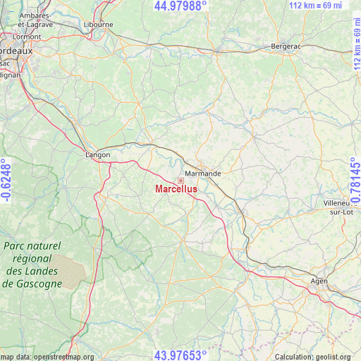
Marcellus GPS coordinates[2]
44° 28' 49.296" North, 0° 4' 41.952" East
| Map corner | latitude | longitude |
|---|---|---|
| Upper-left | 44.97988°, | -0.6248° |
| Center: | 44.48036°, | 0.07832° |
| Lower-right: | 43.97653°, | 0.78145° |
| Map W x H: | 111.6×111.6 km | = 69.3×69.3mi |
| max Lat: | 51.07786° ⇑83.7% North |
| Marcellus: | 44.48036° |
| min Lat: | ⇓16.3% South 41.3874° |
| min Long | Marcellus | max Long |
| -5.08615° | 0.07832° | 9.52242° |
| W 22.6%⇐ | ⇒77.4% E |
Elevation
Elevation of Marcellus is 68 m = 223 ft, and this is 125.7 m = 412 ft below average elevation for this country.
| Max E: |
2333 m = 7654 ft | 74.6% |
| Avg. | 193.7 m = 635 ft | |
| Marcellus | 68 m = 223 ft | |
Min E: |
-1 m = -3 ft | 25.4% |
See also: France elevation on elevation.city.
Geographical zone
Marcellus is located in North temperate zone (between Tropic of Cancer and the Arctic Circle). Distance of this Northern Tropic circle is 2339.8 km =1453.9 mi to South.| Distance of | km | miles | from Marcellus |
|---|---|---|---|
| North Pole | 5061.3 | 3144.9 | to North |
| Arctic Circle | 2455.4 | 1525.7 | to North |
| Tropic Cancer | 2339.8 | 1453.9 | to South |
| Equator | 4945.8 | 3073.2 | to South |


Nearby cities:
15 places around Marcellus: (largest is in red/bold)
• Beaupuy
8.3 km =5.2 mi,  42°
42°
• Bouglon
9.8 km =6.1 mi,  171°
171°
• Castelnau-sur-Gupie
9.8 km =6.1 mi,  26°
26°
• Caumont-sur-Garonne
9.5 km =5.9 mi,  120°
120°
• Cocumont
5.5 km =3.4 mi,  228°
228°
• Fourques-sur-Garonne
7.2 km =4.5 mi, 119°
• Lagupie
8.8 km =5.5 mi,  18°
18°
• Marmande
7.2 km =4.5 mi,  72°
72°
• Meilhan-sur-Garonne
5.7 km =3.5 mi,  322°
322°
• Mongauzy
10.2 km =6.3 mi,  339°
339°
• Montpouillan
2.6 km =1.6 mi, 122°
• Saint-Pardoux-du-Breuil
9.2 km =5.7 mi,  93°
93°
• Sainte-Bazeille
5.8 km =3.6 mi, 15°
• Samazan
5.9 km =3.7 mi,  152°
152°
• Virazeil
11.8 km =7.3 mi,  75°
75°
Sources, notices
• [Note1] Compared only with cities in France existing in our database
• [Src1] Map data: © OpenStreetMap contributors (CC-BY-SA)
• [Src2] Other city data from geonames.org with taken over terms of usage.
• [Src3] Geographical zone / Annual Mean Temperature by Robert A. Rohde @ Wikipedia
