Bouglon geodata
Bouglon (Nouvelle-Aquitaine) is a populated place; located in France in Europe/Paris (GMT+2) time zone. With population of 580 people, there are 13652 cities with bigger population in this country. Compared to other cities in France, 84.3% of cities are located further ↑North; 77.2% of cities are located further →East and 51.4% of cities have lower elevation than Bouglon. Note1
Administrative division(s):
- Level 1: Nouvelle-Aquitaine
- Level 2: Département du Lot-et-Garonne
- Level 3: Arrondissement de Marmande
- Level 4: Bouglon


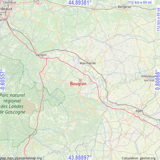
Bouglon GPS coordinates[2]
44° 23' 36.78" North, 0° 5' 51.18" East
| Map corner | latitude | longitude |
|---|---|---|
| Upper-left | 44.89381°, | -0.60557° |
| Center: | 44.39355°, | 0.09755° |
| Lower-right: | 43.88897°, | 0.80068° |
| Map W x H: | 111.7×111.7 km | = 69.4×69.4mi |
| max Lat: | 51.07786° ⇑84.3% North |
| Bouglon: | 44.39355° |
| min Lat: | ⇓15.7% South 41.3874° |
| min Long | Bouglon | max Long |
| -5.08615° | 0.09755° | 9.52242° |
| W 22.8%⇐ | ⇒77.2% E |
Elevation
Elevation of Bouglon is 137 m = 449 ft, and this is 56.7 m = 186 ft below average elevation for this country.
| Max E: |
2333 m = 7654 ft | 48.6% |
| Avg. | 193.7 m = 635 ft | |
| Bouglon | 137 m = 449 ft | |
Min E: |
-1 m = -3 ft | 51.4% |
See also: France elevation on elevation.city.
Geographical zone
Bouglon is located in North temperate zone (between Tropic of Cancer and the Arctic Circle). Distance of this Northern Tropic circle is 2330.2 km =1447.9 mi to South.| Distance of | km | miles | from Bouglon |
|---|---|---|---|
| North Pole | 5071 | 3151 | to North |
| Arctic Circle | 2465.1 | 1531.7 | to North |
| Tropic Cancer | 2330.2 | 1447.9 | to South |
| Equator | 4936.1 | 3067.1 | to South |


Nearby cities:
15 places around Bouglon: (largest is in red/bold)
• Calonges
11.7 km =7.3 mi,  100°
100°
• Casteljaloux
8.5 km =5.3 mi,  186°
186°
• Caumont-sur-Garonne
8.3 km =5.2 mi,  53°
53°
• Cocumont
8.3 km =5.2 mi,  316°
316°
• Fauguerolles
13.2 km =8.2 mi,  65°
65°
• Fourques-sur-Garonne
7.7 km =4.8 mi,  37°
37°
• Grignols
11.2 km =7 mi,  267°
267°
• Le Mas-d’Agenais
9.8 km =6.1 mi,  79°
79°
• Marcellus
9.8 km =6.1 mi,  351°
351°
• Marmande
13 km =8.1 mi,  24°
24°
• Meilhan-sur-Garonne
15.1 km =9.4 mi,  340°
340°
• Montpouillan
8.3 km =5.2 mi,  4°
4°
• Saint-Pardoux-du-Breuil
11.9 km =7.4 mi, 39°
• Samazan
4.6 km =2.9 mi, 15°
• Villeton
15.3 km =9.5 mi, 97°
Sources, notices
• [Note1] Compared only with cities in France existing in our database
• [Src1] Map data: © OpenStreetMap contributors (CC-BY-SA)
• [Src2] Other city data from geonames.org with taken over terms of usage.
• [Src3] Geographical zone / Annual Mean Temperature by Robert A. Rohde @ Wikipedia
