Luzech geodata
Luzech (Occitanie) is a populated place; located in France in Europe/Paris (GMT+2) time zone. With population of 1,758 people, there are 5386 cities with bigger population in this country. Compared to other cities in France, 83.7% of cities are located further ↑North; 65.7% of cities are located further →East and 57.9% of cities have higher elevation than Luzech. Note1
Administrative division(s):
- Level 1: Occitanie
- Level 2: Lot
- Level 3: Arrondissement de Cahors
- Level 4: Luzech


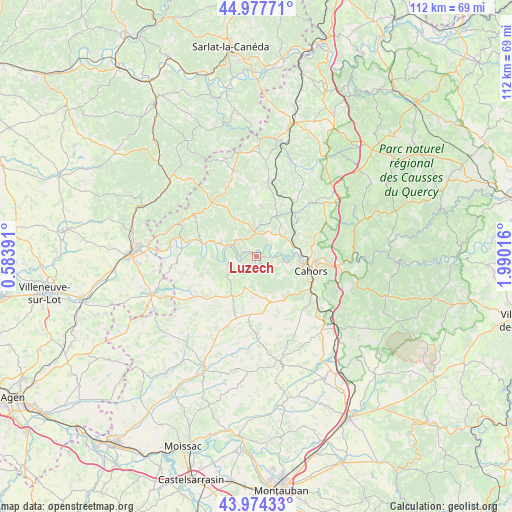
Luzech GPS coordinates[2]
44° 28' 41.448" North, 1° 17' 13.344" East
| Map corner | latitude | longitude |
|---|---|---|
| Upper-left | 44.97771°, | 0.58391° |
| Center: | 44.47818°, | 1.28704° |
| Lower-right: | 43.97433°, | 1.99016° |
| Map W x H: | 111.6×111.6 km | = 69.3×69.3mi |
| max Lat: | 51.07786° ⇑83.7% North |
| Luzech: | 44.47818° |
| min Lat: | ⇓16.3% South 41.3874° |
| min Long | Luzech | max Long |
| -5.08615° | 1.28704° | 9.52242° |
| W 34.3%⇐ | ⇒65.7% E |
Elevation
Elevation of Luzech is 108 m = 354 ft, and this is 85.7 m = 281 ft below average elevation for this country.
| Max E: |
2333 m = 7654 ft | 57.9% |
| Avg. | 193.7 m = 635 ft | |
| Luzech | 108 m = 354 ft | |
Min E: |
-1 m = -3 ft | 42.1% |
See also: France elevation on elevation.city.
Geographical zone
Luzech is located in North temperate zone (between Tropic of Cancer and the Arctic Circle). Distance of this Northern Tropic circle is 2339.6 km =1453.8 mi to South.| Distance of | km | miles | from Luzech |
|---|---|---|---|
| North Pole | 5061.6 | 3145.1 | to North |
| Arctic Circle | 2455.7 | 1525.9 | to North |
| Tropic Cancer | 2339.6 | 1453.8 | to South |
| Equator | 4945.5 | 3073 | to South |


Nearby cities:
15 places around Luzech: (largest is in red/bold)
• Albas
4.1 km =2.5 mi,  255°
255°
• Cahors
12.3 km =7.6 mi,  105°
105°
• Caillac
5.5 km =3.4 mi,  75°
75°
• Catus
9.6 km =6 mi,  24°
24°
• Douelle
5.9 km =3.7 mi,  99°
99°
• Espère
7.7 km =4.8 mi,  61°
61°
• Labastide-Marnhac
13.4 km =8.3 mi,  138°
138°
• Lamagdelaine
16 km =9.9 mi,  94°
94°
• Laroque-des-Arcs
14.4 km =8.9 mi, 90°
• Mercuès
8.1 km =5 mi, 75°
• Montcuq
16.7 km =10.4 mi,  201°
201°
• Pradines
9.1 km =5.7 mi, 86°
• Prayssac
8.3 km =5.2 mi,  290°
290°
• Puy-l’Évêque
12 km =7.5 mi,  284°
284°
• Trespoux-Rassiels
10.3 km =6.4 mi, 135°
Sources, notices
• [Note1] Compared only with cities in France existing in our database
• [Src1] Map data: © OpenStreetMap contributors (CC-BY-SA)
• [Src2] Other city data from geonames.org with taken over terms of usage.
• [Src3] Geographical zone / Annual Mean Temperature by Robert A. Rohde @ Wikipedia
