Douelle geodata
Douelle (Occitanie) is a populated place; located in France in Europe/Paris (GMT+2) time zone. With population of 806 people, there are 10540 cities with bigger population in this country. Compared to other cities in France, 83.8% of cities are located further ↑North; 64.9% of cities are located further →East and 56.2% of cities have higher elevation than Douelle. Note1
Administrative division(s):
- Level 1: Occitanie
- Level 2: Lot
- Level 3: Arrondissement de Cahors
- Level 4: Douelle


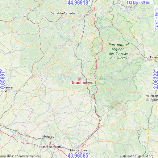
Douelle GPS coordinates[2]
44° 28' 10.452" North, 1° 21' 36.36" East
| Map corner | latitude | longitude |
|---|---|---|
| Upper-left | 44.96918°, | 0.65697° |
| Center: | 44.46957°, | 1.3601° |
| Lower-right: | 43.96565°, | 2.06322° |
| Map W x H: | 111.6×111.6 km | = 69.3×69.3mi |
| max Lat: | 51.07786° ⇑83.8% North |
| Douelle: | 44.46957° |
| min Lat: | ⇓16.2% South 41.3874° |
| min Long | Douelle | max Long |
| -5.08615° | 1.3601° | 9.52242° |
| W 35.1%⇐ | ⇒64.9% E |
Elevation
Elevation of Douelle is 113 m = 371 ft, and this is 80.7 m = 265 ft below average elevation for this country.
| Max E: |
2333 m = 7654 ft | 56.2% |
| Avg. | 193.7 m = 635 ft | |
| Douelle | 113 m = 371 ft | |
Min E: |
-1 m = -3 ft | 43.8% |
See also: France elevation on elevation.city.
Geographical zone
Douelle is located in North temperate zone (between Tropic of Cancer and the Arctic Circle). Distance of this Northern Tropic circle is 2338.6 km =1453.1 mi to South.| Distance of | km | miles | from Douelle |
|---|---|---|---|
| North Pole | 5062.5 | 3145.7 | to North |
| Arctic Circle | 2456.6 | 1526.5 | to North |
| Tropic Cancer | 2338.6 | 1453.1 | to South |
| Equator | 4944.6 | 3072.4 | to South |


Nearby cities:
15 places around Douelle: (largest is in red/bold)
• Albas
9.8 km =6.1 mi,  269°
269°
• Arcambal
12.2 km =7.6 mi,  97°
97°
• Cahors
6.5 km =4 mi,  110°
110°
• Caillac
2.4 km =1.5 mi,  348°
348°
• Catus
9.9 km =6.2 mi, 349°
• Espère
4.7 km =2.9 mi,  11°
11°
• Flaujac-Poujols
13.2 km =8.2 mi,  122°
122°
• Labastide-Marnhac
9.6 km =6 mi,  160°
160°
• Lamagdelaine
10.2 km =6.3 mi,  91°
91°
• Laroque-des-Arcs
8.6 km =5.3 mi,  84°
84°
• Le Montat
12.2 km =7.6 mi,  144°
144°
• Luzech
5.9 km =3.7 mi,  279°
279°
• Mercuès
3.7 km =2.3 mi,  34°
34°
• Pradines
3.6 km =2.2 mi,  64°
64°
• Trespoux-Rassiels
6.5 km =4 mi,  167°
167°
Sources, notices
• [Note1] Compared only with cities in France existing in our database
• [Src1] Map data: © OpenStreetMap contributors (CC-BY-SA)
• [Src2] Other city data from geonames.org with taken over terms of usage.
• [Src3] Geographical zone / Annual Mean Temperature by Robert A. Rohde @ Wikipedia
