Luneray geodata
Luneray (Normandy) is a populated place; located in France in Europe/Paris (GMT+2) time zone. With population of 2,087 people, there are 4615 cities with bigger population in this country. Compared to other cities in France, 92.5% of cities are located further ↓South; 69.6% of cities are located further →East and 71% of cities have higher elevation than Luneray. Note1
Administrative division(s):
- Level 1: Normandy
- Level 2: Seine-Maritime
- Level 3: Arrondissement de Dieppe
- Level 4: Luneray


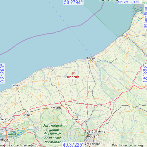
Luneray GPS coordinates[2]
49° 49' 40.62" North, 0° 54' 56.916" East
| Map corner | latitude | longitude |
|---|---|---|
| Upper-left | 50.2794°, | 0.21268° |
| Center: | 49.82795°, | 0.91581° |
| Lower-right: | 49.37225°, | 1.61893° |
| Map W x H: | 100.9×100.9 km | = 62.7×62.7mi |
| max Lat: | 51.07786° ⇑7.5% North |
| Luneray: | 49.82795° |
| min Lat: | ⇓92.5% South 41.3874° |
| min Long | Luneray | max Long |
| -5.08615° | 0.91581° | 9.52242° |
| W 30.4%⇐ | ⇒69.6% E |
Elevation
Elevation of Luneray is 76 m = 249 ft, and this is 117.7 m = 386 ft below average elevation for this country.
| Max E: |
2333 m = 7654 ft | 71% |
| Avg. | 193.7 m = 635 ft | |
| Luneray | 76 m = 249 ft | |
Min E: |
-1 m = -3 ft | 29% |
See also: France elevation on elevation.city.
Geographical zone
Luneray is located in North temperate zone (between Tropic of Cancer and the Arctic Circle). Distance of this North polar circle is 1860.8 km =1156.2 mi to North.| Distance of | km | miles | from Luneray |
|---|---|---|---|
| North Pole | 4466.7 | 2775.5 | to North |
| Arctic Circle | 1860.8 | 1156.2 | to North |
| Tropic Cancer | 2934.4 | 1823.4 | to South |
| Equator | 5540.3 | 3442.6 | to South |


Nearby cities:
15 places around Luneray: (largest is in red/bold)
• Angiens
9 km =5.6 mi,  269°
269°
• Auppegard
8 km =5 mi,  88°
88°
• Avremesnil
2.6 km =1.6 mi,  20°
20°
• Bacqueville-en-Caux
7.5 km =4.7 mi,  126°
126°
• Brachy
2.8 km =1.7 mi,  117°
117°
• Fontaine-le-Dun
5 km =3.1 mi,  248°
248°
• Gruchet-Saint-Siméon
1.9 km =1.2 mi,  237°
237°
• Gueures
3.8 km =2.4 mi,  61°
61°
• Longueil
7.2 km =4.5 mi,  30°
30°
• Offranville
10.7 km =6.6 mi, 62°
• Ouville-la-Rivière
6 km =3.7 mi, 31°
• Saint-Laurent-en-Caux
8.9 km =5.5 mi,  196°
196°
• Sainte-Marguerite-sur-Mer
9.3 km =5.8 mi,  13°
13°
• Varengeville-sur-Mer
10.2 km =6.3 mi, 33°
• Veules-les-Roses
9.7 km =6 mi,  300°
300°
Sources, notices
• [Note1] Compared only with cities in France existing in our database
• [Src1] Map data: © OpenStreetMap contributors (CC-BY-SA)
• [Src2] Other city data from geonames.org with taken over terms of usage.
• [Src3] Geographical zone / Annual Mean Temperature by Robert A. Rohde @ Wikipedia
