Fontaine-le-Dun geodata
Fontaine-le-Dun (Normandy) is a populated place; located in France in Europe/Paris (GMT+2) time zone. With population of 1,025 people, there are 8651 cities with bigger population in this country. Compared to other cities in France, 92.3% of cities are located further ↓South; 70.2% of cities are located further →East and 80.6% of cities have higher elevation than Fontaine-le-Dun. Note1
Administrative division(s):
- Level 1: Normandy
- Level 2: Seine-Maritime
- Level 3: Arrondissement de Dieppe
- Level 4: Fontaine-le-Dun


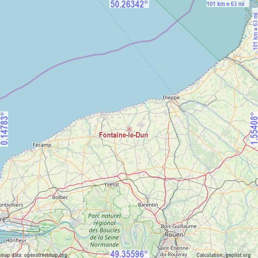
Fontaine-le-Dun GPS coordinates[2]
49° 48' 42.552" North, 0° 51' 3.42" East
| Map corner | latitude | longitude |
|---|---|---|
| Upper-left | 50.26342°, | 0.14783° |
| Center: | 49.81182°, | 0.85095° |
| Lower-right: | 49.35596°, | 1.55408° |
| Map W x H: | 100.9×100.9 km | = 62.7×62.7mi |
| max Lat: | 51.07786° ⇑7.7% North |
| Fontaine-le-Dun: | 49.81182° |
| min Lat: | ⇓92.3% South 41.3874° |
| min Long | Fontaine-le-Dun | max Long |
| -5.08615° | 0.85095° | 9.52242° |
| W 29.8%⇐ | ⇒70.2% E |
Elevation
Elevation of Fontaine-le-Dun is 53 m = 174 ft, and this is 140.7 m = 462 ft below average elevation for this country.
| Max E: |
2333 m = 7654 ft | 80.6% |
| Avg. | 193.7 m = 635 ft | |
| Fontaine-le-Dun | 53 m = 174 ft | |
Min E: |
-1 m = -3 ft | 19.4% |
See also: France elevation on elevation.city.
Geographical zone
Fontaine-le-Dun is located in North temperate zone (between Tropic of Cancer and the Arctic Circle). Distance of this North polar circle is 1862.6 km =1157.4 mi to North.| Distance of | km | miles | from Fontaine-le-Dun |
|---|---|---|---|
| North Pole | 4468.5 | 2776.6 | to North |
| Arctic Circle | 1862.6 | 1157.4 | to North |
| Tropic Cancer | 2932.6 | 1822.2 | to South |
| Equator | 5538.6 | 3441.5 | to South |


Nearby cities:
15 places around Fontaine-le-Dun: (largest is in red/bold)
• Angiens
4.7 km =2.9 mi,  291°
291°
• Avremesnil
7 km =4.3 mi,  52°
52°
• Bacqueville-en-Caux
11 km =6.8 mi,  104°
104°
• Brachy
7.1 km =4.4 mi,  85°
85°
• Doudeville
11 km =6.8 mi,  205°
205°
• Gruchet-Saint-Siméon
3.2 km =2 mi,  75°
75°
• Gueures
8.7 km =5.4 mi,  65°
65°
• Longueil
11.5 km =7.1 mi, 46°
• Luneray
5 km =3.1 mi, 68°
• Néville
10.3 km =6.4 mi,  277°
277°
• Ouville-la-Rivière
10.4 km =6.5 mi, 48°
• Saint-Laurent-en-Caux
7.1 km =4.4 mi,  162°
162°
• Saint-Valery-en-Caux
10.4 km =6.5 mi,  305°
305°
• Sainte-Marguerite-sur-Mer
12.8 km =8 mi,  32°
32°
• Veules-les-Roses
7.7 km =4.8 mi,  331°
331°
Sources, notices
• [Note1] Compared only with cities in France existing in our database
• [Src1] Map data: © OpenStreetMap contributors (CC-BY-SA)
• [Src2] Other city data from geonames.org with taken over terms of usage.
• [Src3] Geographical zone / Annual Mean Temperature by Robert A. Rohde @ Wikipedia
