Bacqueville-en-Caux geodata
Bacqueville-en-Caux (Normandy) is a populated place; located in France in Europe/Paris (GMT+2) time zone. With population of 1,799 people, there are 5278 cities with bigger population in this country. Compared to other cities in France, 92.2% of cities are located further ↓South; 68.8% of cities are located further →East and 62% of cities have higher elevation than Bacqueville-en-Caux. Note1
Administrative division(s):
- Level 1: Normandy
- Level 2: Seine-Maritime
- Level 3: Arrondissement de Dieppe
- Level 4: Bacqueville-en-Caux


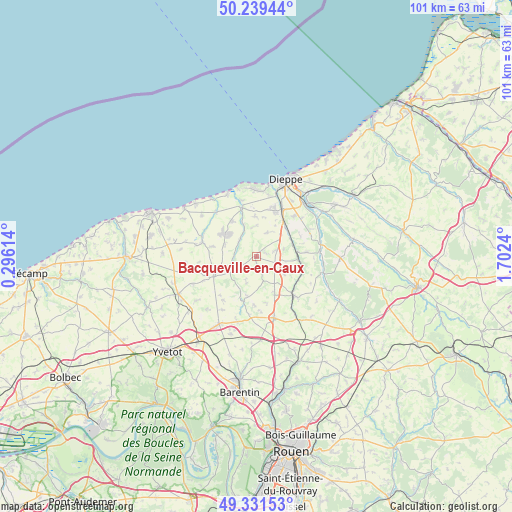
Bacqueville-en-Caux GPS coordinates[2]
49° 47' 15.396" North, 0° 59' 57.372" East
| Map corner | latitude | longitude |
|---|---|---|
| Upper-left | 50.23944°, | 0.29614° |
| Center: | 49.78761°, | 0.99927° |
| Lower-right: | 49.33153°, | 1.7024° |
| Map W x H: | 101×100.9 km | = 62.8×62.7mi |
| max Lat: | 51.07786° ⇑7.8% North |
| Bacqueville-en-Caux: | 49.78761° |
| min Lat: | ⇓92.2% South 41.3874° |
| min Long | Bacqueville-en- | max Long |
| -5.08615° | 0.99927° | 9.52242° |
| W 31.2%⇐ | ⇒68.8% E |
Elevation
Elevation of Bacqueville-en-Caux is 97 m = 318 ft, and this is 96.7 m = 317 ft below average elevation for this country.
| Max E: |
2333 m = 7654 ft | 62% |
| Avg. | 193.7 m = 635 ft | |
| Bacqueville-en-Caux | 97 m = 318 ft | |
Min E: |
-1 m = -3 ft | 38% |
See also: France elevation on elevation.city.
Geographical zone
Bacqueville-en-Caux is located in North temperate zone (between Tropic of Cancer and the Arctic Circle). Distance of this North polar circle is 1865.3 km =1159 mi to North.| Distance of | km | miles | from Bacqueville-en-Caux |
|---|---|---|---|
| North Pole | 4471.2 | 2778.3 | to North |
| Arctic Circle | 1865.3 | 1159 | to North |
| Tropic Cancer | 2929.9 | 1820.6 | to South |
| Equator | 5535.9 | 3439.8 | to South |


Nearby cities:
15 places around Bacqueville-en-Caux: (largest is in red/bold)
• Auffay
10.5 km =6.5 mi,  136°
136°
• Auppegard
5.1 km =3.2 mi,  23°
23°
• Avremesnil
8.6 km =5.3 mi,  323°
323°
• Biville-la-Baignarde
8.1 km =5 mi,  154°
154°
• Brachy
4.8 km =3 mi,  312°
312°
• Gruchet-Saint-Siméon
8.3 km =5.2 mi,  294°
294°
• Gueures
6.9 km =4.3 mi,  336°
336°
• Heugleville-sur-Scie
8.9 km =5.5 mi,  133°
133°
• Longueville-sur-Scie
8 km =5 mi,  86°
86°
• Luneray
7.5 km =4.7 mi, 306°
• Offranville
10 km =6.2 mi, 20°
• Ouville-la-Rivière
10 km =6.2 mi, 343°
• Saint-Aubin-sur-Scie
10.6 km =6.6 mi,  27°
27°
• Saint-Laurent-en-Caux
9.5 km =5.9 mi,  244°
244°
• Tourville-sur-Arques
10.9 km =6.8 mi,  42°
42°
Sources, notices
• [Note1] Compared only with cities in France existing in our database
• [Src1] Map data: © OpenStreetMap contributors (CC-BY-SA)
• [Src2] Other city data from geonames.org with taken over terms of usage.
• [Src3] Geographical zone / Annual Mean Temperature by Robert A. Rohde @ Wikipedia
