Luc-sur-Mer geodata
Luc-sur-Mer (Normandy) is a populated place; located in France in Europe/Paris (GMT+2) time zone. With population of 3,171 people, there are 3069 cities with bigger population in this country. Compared to other cities in France, 86.4% of cities are located further ↓South; 81.5% of cities are located further →East and 97% of cities have higher elevation than Luc-sur-Mer. Note1
Administrative division(s):
- Level 1: Normandy
- Level 2: Calvados
- Level 3: Arrondissement de Caen
- Level 4: Luc-sur-Mer


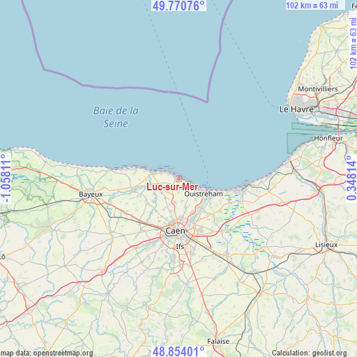
Luc-sur-Mer GPS coordinates[2]
49° 18' 52.272" North, 0° 21' 17.964" West
| Map corner | latitude | longitude |
|---|---|---|
| Upper-left | 49.77076°, | -1.05811° |
| Center: | 49.31452°, | -0.35499° |
| Lower-right: | 48.85401°, | 0.34814° |
| Map W x H: | 101.9×101.9 km | = 63.3×63.3mi |
| max Lat: | 51.07786° ⇑13.6% North |
| Luc-sur-Mer: | 49.31452° |
| min Lat: | ⇓86.4% South 41.3874° |
| min Long | Luc-sur-Mer | max Long |
| -5.08615° | -0.35499° | 9.52242° |
| W 18.5%⇐ | ⇒81.5% E |
Elevation
Elevation of Luc-sur-Mer is 11 m = 36 ft, and this is 182.7 m = 599 ft below average elevation for this country.
| Max E: |
2333 m = 7654 ft | 97% |
| Avg. | 193.7 m = 635 ft | |
| Luc-sur-Mer | 11 m = 36 ft | |
Min E: |
-1 m = -3 ft | 3% |
See also: France elevation on elevation.city.
Geographical zone
Luc-sur-Mer is located in North temperate zone (between Tropic of Cancer and the Arctic Circle). Distance of this North polar circle is 1917.9 km =1191.7 mi to North.| Distance of | km | miles | from Luc-sur-Mer |
|---|---|---|---|
| North Pole | 4523.8 | 2811 | to North |
| Arctic Circle | 1917.9 | 1191.7 | to North |
| Tropic Cancer | 2877.3 | 1787.9 | to South |
| Equator | 5483.3 | 3407.2 | to South |


Nearby cities:
15 places around Luc-sur-Mer: (largest is in red/bold)
• Anguerny
6.3 km =3.9 mi,  212°
212°
• Anisy
7.6 km =4.7 mi,  200°
200°
• Basly
6.4 km =4 mi,  231°
231°
• Bernières-sur-Mer
5.2 km =3.2 mi,  289°
289°
• Beuville
8.2 km =5.1 mi,  164°
164°
• Colleville-Montgomery
5.9 km =3.7 mi,  137°
137°
• Courseulles-sur-Mer
7.5 km =4.7 mi,  283°
283°
• Cresserons
3.1 km =1.9 mi,  180°
180°
• Douvres-la-Délivrande
2.9 km =1.8 mi,  219°
219°
• Hermanville-sur-Mer
4.4 km =2.7 mi, 139°
• Langrune-sur-Mer
1.7 km =1.1 mi,  306°
306°
• Lion-sur-Mer
2.9 km =1.8 mi,  123°
123°
• Mathieu
6.8 km =4.2 mi,  190°
190°
• Ouistreham
8.2 km =5.1 mi, 121°
• Saint-Aubin-sur-Mer
2.8 km =1.7 mi,  302°
302°
Sources, notices
• [Note1] Compared only with cities in France existing in our database
• [Src1] Map data: © OpenStreetMap contributors (CC-BY-SA)
• [Src2] Other city data from geonames.org with taken over terms of usage.
• [Src3] Geographical zone / Annual Mean Temperature by Robert A. Rohde @ Wikipedia
