Anguerny geodata
Anguerny (Normandy) is a populated place; located in France in Europe/Paris (GMT+2) time zone. With population of 757 people, there are 11093 cities with bigger population in this country. Compared to other cities in France, 85.4% of cities are located further ↓South; 82.1% of cities are located further →East and 78.2% of cities have higher elevation than Anguerny. Note1
Administrative division(s):
- Level 1: Normandy
- Level 2: Calvados
- Level 3: Arrondissement de Caen
- Level 4: Colomby-Anguerny


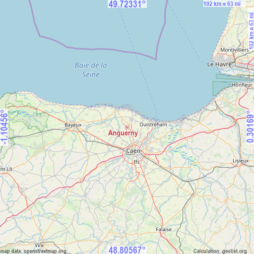
Anguerny GPS coordinates[2]
49° 15' 59.832" North, 0° 24' 5.148" West
| Map corner | latitude | longitude |
|---|---|---|
| Upper-left | 49.72331°, | -1.10456° |
| Center: | 49.26662°, | -0.40143° |
| Lower-right: | 48.80567°, | 0.30169° |
| Map W x H: | 102×102 km | = 63.4×63.4mi |
| max Lat: | 51.07786° ⇑14.6% North |
| Anguerny: | 49.26662° |
| min Lat: | ⇓85.4% South 41.3874° |
| min Long | Anguerny | max Long |
| -5.08615° | -0.40143° | 9.52242° |
| W 17.9%⇐ | ⇒82.1% E |
Elevation
Elevation of Anguerny is 59 m = 194 ft, and this is 134.7 m = 442 ft below average elevation for this country.
| Max E: |
2333 m = 7654 ft | 78.2% |
| Avg. | 193.7 m = 635 ft | |
| Anguerny | 59 m = 194 ft | |
Min E: |
-1 m = -3 ft | 21.8% |
See also: France elevation on elevation.city.
Geographical zone
Anguerny is located in North temperate zone (between Tropic of Cancer and the Arctic Circle). Distance of this North polar circle is 1923.2 km =1195 mi to North.| Distance of | km | miles | from Anguerny |
|---|---|---|---|
| North Pole | 4529.1 | 2814.3 | to North |
| Arctic Circle | 1923.2 | 1195 | to North |
| Tropic Cancer | 2872 | 1784.6 | to South |
| Equator | 5477.9 | 3403.8 | to South |


Nearby cities:
15 places around Anguerny: (largest is in red/bold)
• Anisy
1.9 km =1.2 mi,  157°
157°
• Basly
2.1 km =1.3 mi,  310°
310°
• Beuville
6.1 km =3.8 mi,  114°
114°
• Biéville-Beuville
6 km =3.7 mi,  116°
116°
• Cairon
4.6 km =2.9 mi,  230°
230°
• Cambes-en-Plaine
4.1 km =2.5 mi, 163°
• Cresserons
4 km =2.5 mi,  55°
55°
• Douvres-la-Délivrande
3.5 km =2.2 mi,  26°
26°
• Fontaine-Henry
3.8 km =2.4 mi,  285°
285°
• Mathieu
2.5 km =1.6 mi, 122°
• Rosel
5.9 km =3.7 mi,  224°
224°
• Saint-Contest
5.8 km =3.6 mi,  180°
180°
• Thaon
4.1 km =2.5 mi,  256°
256°
• Villons-les-Buissons
3 km =1.9 mi,  191°
191°
• Épron
5.5 km =3.4 mi, 156°
Sources, notices
• [Note1] Compared only with cities in France existing in our database
• [Src1] Map data: © OpenStreetMap contributors (CC-BY-SA)
• [Src2] Other city data from geonames.org with taken over terms of usage.
• [Src3] Geographical zone / Annual Mean Temperature by Robert A. Rohde @ Wikipedia
