Cresserons geodata
Cresserons (Normandy) is a populated place; located in France in Europe/Paris (GMT+2) time zone. With population of 1,255 people, there are 7259 cities with bigger population in this country. Compared to other cities in France, 85.8% of cities are located further ↓South; 81.5% of cities are located further →East and 89.9% of cities have higher elevation than Cresserons. Note1
Administrative division(s):
- Level 1: Normandy
- Level 2: Calvados
- Level 3: Arrondissement de Caen
- Level 4: Cresserons


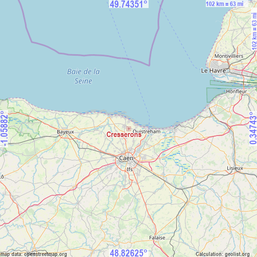
Cresserons GPS coordinates[2]
49° 17' 13.236" North, 0° 21' 20.484" West
| Map corner | latitude | longitude |
|---|---|---|
| Upper-left | 49.74351°, | -1.05882° |
| Center: | 49.28701°, | -0.35569° |
| Lower-right: | 48.82625°, | 0.34743° |
| Map W x H: | 102×102 km | = 63.4×63.4mi |
| max Lat: | 51.07786° ⇑14.2% North |
| Cresserons: | 49.28701° |
| min Lat: | ⇓85.8% South 41.3874° |
| min Long | Cresserons | max Long |
| -5.08615° | -0.35569° | 9.52242° |
| W 18.5%⇐ | ⇒81.5% E |
Elevation
Elevation of Cresserons is 30 m = 98 ft, and this is 163.7 m = 537 ft below average elevation for this country.
| Max E: |
2333 m = 7654 ft | 89.9% |
| Avg. | 193.7 m = 635 ft | |
| Cresserons | 30 m = 98 ft | |
Min E: |
-1 m = -3 ft | 10.1% |
See also: France elevation on elevation.city.
Geographical zone
Cresserons is located in North temperate zone (between Tropic of Cancer and the Arctic Circle). Distance of this North polar circle is 1921 km =1193.7 mi to North.| Distance of | km | miles | from Cresserons |
|---|---|---|---|
| North Pole | 4526.9 | 2812.9 | to North |
| Arctic Circle | 1921 | 1193.7 | to North |
| Tropic Cancer | 2874.3 | 1786 | to South |
| Equator | 5480.2 | 3405.2 | to South |


Nearby cities:
15 places around Cresserons: (largest is in red/bold)
• Anguerny
4 km =2.5 mi,  235°
235°
• Anisy
4.8 km =3 mi,  212°
212°
• Basly
5 km =3.1 mi,  259°
259°
• Beuville
5.3 km =3.3 mi,  155°
155°
• Biéville-Beuville
5.3 km =3.3 mi, 157°
• Cambes-en-Plaine
6.5 km =4 mi,  199°
199°
• Colleville-Montgomery
4.2 km =2.6 mi,  108°
108°
• Douvres-la-Délivrande
2 km =1.2 mi,  295°
295°
• Hermanville-sur-Mer
2.9 km =1.8 mi,  95°
95°
• Langrune-sur-Mer
4.3 km =2.7 mi,  342°
342°
• Lion-sur-Mer
2.9 km =1.8 mi,  59°
59°
• Luc-sur-Mer
3.1 km =1.9 mi,  0°
0°
• Mathieu
3.8 km =2.4 mi, 197°
• Saint-Aubin-sur-Mer
5.1 km =3.2 mi,  333°
333°
• Villons-les-Buissons
6.5 km =4 mi,  217°
217°
Sources, notices
• [Note1] Compared only with cities in France existing in our database
• [Src1] Map data: © OpenStreetMap contributors (CC-BY-SA)
• [Src2] Other city data from geonames.org with taken over terms of usage.
• [Src3] Geographical zone / Annual Mean Temperature by Robert A. Rohde @ Wikipedia
