Anisy geodata
Anisy (Normandy) is a populated place; located in France in Europe/Paris (GMT+2) time zone. With population of 679 people, there are 12079 cities with bigger population in this country. Compared to other cities in France, 85.2% of cities are located further ↓South; 82% of cities are located further →East and 81.8% of cities have higher elevation than Anisy. Note1
Administrative division(s):
- Level 1: Normandy
- Level 2: Calvados
- Level 3: Arrondissement de Caen
- Level 4: Anisy


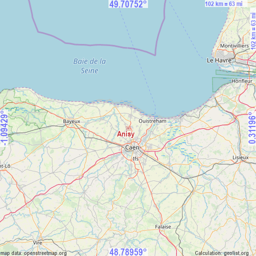
Anisy GPS coordinates[2]
49° 15' 2.484" North, 0° 23' 28.176" West
| Map corner | latitude | longitude |
|---|---|---|
| Upper-left | 49.70752°, | -1.09429° |
| Center: | 49.25069°, | -0.39116° |
| Lower-right: | 48.78959°, | 0.31196° |
| Map W x H: | 102.1×102.1 km | = 63.4×63.4mi |
| max Lat: | 51.07786° ⇑14.8% North |
| Anisy: | 49.25069° |
| min Lat: | ⇓85.2% South 41.3874° |
| min Long | Anisy | max Long |
| -5.08615° | -0.39116° | 9.52242° |
| W 18%⇐ | ⇒82% E |
Elevation
Elevation of Anisy is 50 m = 164 ft, and this is 143.7 m = 471 ft below average elevation for this country.
| Max E: |
2333 m = 7654 ft | 81.8% |
| Avg. | 193.7 m = 635 ft | |
| Anisy | 50 m = 164 ft | |
Min E: |
-1 m = -3 ft | 18.2% |
See also: France elevation on elevation.city.
Geographical zone
Anisy is located in North temperate zone (between Tropic of Cancer and the Arctic Circle). Distance of this North polar circle is 1925 km =1196.1 mi to North.| Distance of | km | miles | from Anisy |
|---|---|---|---|
| North Pole | 4530.9 | 2815.4 | to North |
| Arctic Circle | 1925 | 1196.1 | to North |
| Tropic Cancer | 2870.2 | 1783.5 | to South |
| Equator | 5476.2 | 3402.8 | to South |


Nearby cities:
15 places around Anisy: (largest is in red/bold)
• Anguerny
1.9 km =1.2 mi,  337°
337°
• Basly
3.9 km =2.4 mi,  323°
323°
• Beuville
4.8 km =3 mi,  99°
99°
• Biéville-Beuville
4.7 km =2.9 mi, 100°
• Cairon
4.5 km =2.8 mi,  254°
254°
• Cambes-en-Plaine
2.2 km =1.4 mi,  168°
168°
• Cresserons
4.8 km =3 mi,  32°
32°
• Douvres-la-Délivrande
5 km =3.1 mi,  9°
9°
• Fontaine-Henry
5.2 km =3.2 mi,  302°
302°
• Mathieu
1.5 km =0.9 mi,  73°
73°
• Rosel
5.5 km =3.4 mi,  243°
243°
• Saint-Contest
4.2 km =2.6 mi,  191°
191°
• Thaon
4.8 km =3 mi,  279°
279°
• Villons-les-Buissons
1.8 km =1.1 mi,  229°
229°
• Épron
3.5 km =2.2 mi,  155°
155°
Sources, notices
• [Note1] Compared only with cities in France existing in our database
• [Src1] Map data: © OpenStreetMap contributors (CC-BY-SA)
• [Src2] Other city data from geonames.org with taken over terms of usage.
• [Src3] Geographical zone / Annual Mean Temperature by Robert A. Rohde @ Wikipedia
