Lion-sur-Mer geodata
Lion-sur-Mer (Normandy) is a populated place; located in France in Europe/Paris (GMT+2) time zone. With population of 2,534 people, there are 3845 cities with bigger population in this country. Compared to other cities in France, 86.1% of cities are located further ↓South; 81.1% of cities are located further →East and 97.4% of cities have higher elevation than Lion-sur-Mer. Note1
Administrative division(s):
- Level 1: Normandy
- Level 2: Calvados
- Level 3: Arrondissement de Caen
- Level 4: Lion-sur-Mer


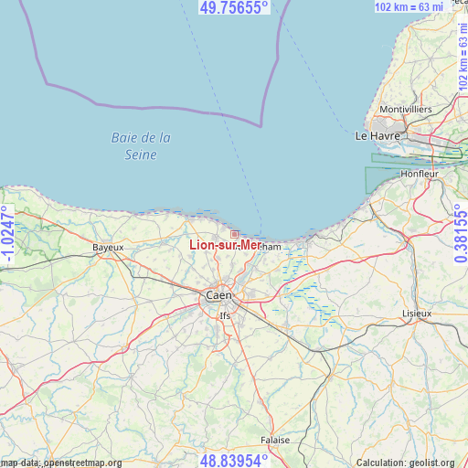
Lion-sur-Mer GPS coordinates[2]
49° 18' 0.648" North, 0° 19' 17.652" West
| Map corner | latitude | longitude |
|---|---|---|
| Upper-left | 49.75655°, | -1.0247° |
| Center: | 49.30018°, | -0.32157° |
| Lower-right: | 48.83954°, | 0.38155° |
| Map W x H: | 102×102 km | = 63.4×63.4mi |
| max Lat: | 51.07786° ⇑13.9% North |
| Lion-sur-Mer: | 49.30018° |
| min Lat: | ⇓86.1% South 41.3874° |
| min Long | Lion-sur-Mer | max Long |
| -5.08615° | -0.32157° | 9.52242° |
| W 18.9%⇐ | ⇒81.1% E |
Elevation
Elevation of Lion-sur-Mer is 10 m = 33 ft, and this is 183.7 m = 603 ft below average elevation for this country.
| Max E: |
2333 m = 7654 ft | 97.4% |
| Avg. | 193.7 m = 635 ft | |
| Lion-sur-Mer | 10 m = 33 ft | |
Min E: |
-1 m = -3 ft | 2.6% |
See also: France elevation on elevation.city.
Geographical zone
Lion-sur-Mer is located in North temperate zone (between Tropic of Cancer and the Arctic Circle). Distance of this North polar circle is 1919.5 km =1192.7 mi to North.| Distance of | km | miles | from Lion-sur-Mer |
|---|---|---|---|
| North Pole | 4525.4 | 2812 | to North |
| Arctic Circle | 1919.5 | 1192.7 | to North |
| Tropic Cancer | 2875.7 | 1786.9 | to South |
| Equator | 5481.7 | 3406.2 | to South |


Nearby cities:
15 places around Lion-sur-Mer: (largest is in red/bold)
• Anguerny
6.9 km =4.3 mi,  237°
237°
• Anisy
7.5 km =4.7 mi,  222°
222°
• Basly
7.8 km =4.8 mi,  251°
251°
• Beuville
6.3 km =3.9 mi,  182°
182°
• Biéville-Beuville
6.4 km =4 mi, 183°
• Bénouville
7.1 km =4.4 mi,  156°
156°
• Colleville-Montgomery
3.2 km =2 mi,  151°
151°
• Cresserons
2.9 km =1.8 mi, 239°
• Douvres-la-Délivrande
4.3 km =2.7 mi,  261°
261°
• Hermanville-sur-Mer
1.8 km =1.1 mi,  165°
165°
• Langrune-sur-Mer
4.6 km =2.9 mi,  304°
304°
• Luc-sur-Mer
2.9 km =1.8 mi, 303°
• Mathieu
6.3 km =3.9 mi, 215°
• Ouistreham
5.3 km =3.3 mi,  121°
121°
• Saint-Aubin-sur-Mer
5.7 km =3.5 mi, 303°
Sources, notices
• [Note1] Compared only with cities in France existing in our database
• [Src1] Map data: © OpenStreetMap contributors (CC-BY-SA)
• [Src2] Other city data from geonames.org with taken over terms of usage.
• [Src3] Geographical zone / Annual Mean Temperature by Robert A. Rohde @ Wikipedia
