Saint-Georges-des-Sept-Voies geodata
Saint-Georges-des-Sept-Voies (Pays de la Loire) is a populated place; located in France in Europe/Paris (GMT+2) time zone. With population of 599 people, there are 13333 cities with bigger population in this country. Compared to other cities in France, 50.8% of cities are located further ↑North; 80.7% of cities are located further →East and 77% of cities have higher elevation than Saint-Georges-des-Sept-Voies. Note1
Administrative division(s):
- Level 1: Pays de la Loire
- Level 2: Département de Maine-et-Loire
- Level 3: Arrondissement de Saumur
- Level 4: Gennes-Val-de-Loire
Current local time in Saint-Georges-des-Sept-Voies:
01:01 PM, SaturdayDifference from your time zone: hours


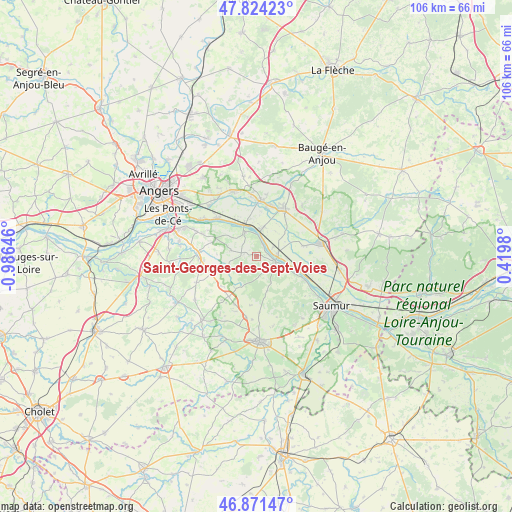
Saint-Georges-des-Sept-Voies GPS coordinates[2]
47° 21' 0" North, 0° 16' 59.988" West
| Map corner | latitude | longitude |
|---|---|---|
| Upper-left | 47.82423°, | -0.98646° |
| Center: | 47.35°, | -0.28333° |
| Lower-right: | 46.87147°, | 0.4198° |
| Map W x H: | 105.9×105.9 km | = 65.8×65.8mi |
| max Lat: | 51.07786° ⇑50.8% North |
| Saint-Georges-des-Sept-Voies: | 47.35° |
| min Lat: | ⇓49.2% South 41.3874° |
| min Long | Saint-Georges-d | max Long |
| -5.08615° | -0.28333° | 9.52242° |
| W 19.3%⇐ | ⇒80.7% E |
Elevation
Elevation of Saint-Georges-des-Sept-Voies is 62 m = 203 ft, and this is 131.7 m = 432 ft below average elevation for this country.
| Max E: |
2333 m = 7654 ft | 77% |
| Avg. | 193.7 m = 635 ft | |
| Saint-Georges-des-Sept-Voies | 62 m = 203 ft | |
Min E: |
-1 m = -3 ft | 23% |
See also: France elevation on elevation.city.
Geographical zone
Saint-Georges-des-Sept-Voies is located in North temperate zone (between Tropic of Cancer and the Arctic Circle). Distance of this North polar circle is 2136.3 km =1327.4 mi to North.| Distance of | km | miles | from Saint-Georges-des-Sept-Voies |
|---|---|---|---|
| North Pole | 4742.2 | 2946.7 | to North |
| Arctic Circle | 2136.3 | 1327.4 | to North |
| Tropic Cancer | 2658.9 | 1652.2 | to South |
| Equator | 5264.8 | 3271.4 | to South |


Nearby cities:
15 places around Saint-Georges-des-Sept-Voies: (largest is in red/bold)
• Ambillou-Château
10.8 km =6.7 mi,  205°
205°
• Beaufort-en-Vallée
11.1 km =6.9 mi,  25°
25°
• Blaison-Gohier
9 km =5.6 mi,  307°
307°
• Charcé-Saint-Ellier-sur-Aubance
9.7 km =6 mi,  275°
275°
• Chemellier
5.7 km =3.5 mi,  259°
259°
• Chênehutte-Trèves-Cunault
10.2 km =6.3 mi,  115°
115°
• Coutures
5.6 km =3.5 mi, 284°
• Gennes
4.1 km =2.5 mi,  105°
105°
• La Ménitré
5.7 km =3.5 mi,  12°
12°
• Les Alleuds
10 km =6.2 mi,  249°
249°
• Les Rosiers-sur-Loire
5 km =3.1 mi,  90°
90°
• Saint-Clément-des-Levées
7.8 km =4.8 mi,  103°
103°
• Saint-Martin-de-la-Place
10.8 km =6.7 mi, 109°
• Saint-Mathurin-sur-Loire
7.8 km =4.8 mi,  341°
341°
• Saint-Rémy-la-Varenne
5.8 km =3.6 mi, 335°
Sources, notices
• [Note1] Compared only with cities in France existing in our database
• [Src1] Map data: © OpenStreetMap contributors (CC-BY-SA)
• [Src2] Other city data from geonames.org with taken over terms of usage.
• [Src3] Geographical zone / Annual Mean Temperature by Robert A. Rohde @ Wikipedia
