Chemellier geodata
Chemellier (Pays de la Loire) is a populated place; located in France in Europe/Paris (GMT+2) time zone. With population of 654 people, there are 12467 cities with bigger population in this country. Compared to other cities in France, 50.9% of cities are located further ↑North; 81.5% of cities are located further →East and 78.6% of cities have higher elevation than Chemellier. Note1
Administrative division(s):
- Level 1: Pays de la Loire
- Level 2: Département de Maine-et-Loire
- Level 3: Angers
- Level 4: Brissac Loire Aubance


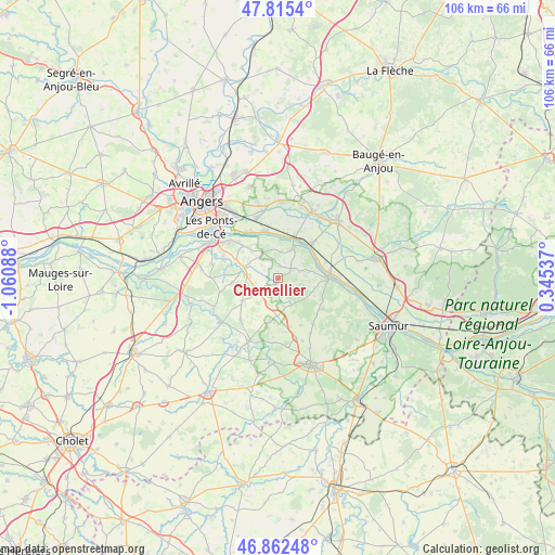
Chemellier GPS coordinates[2]
47° 20' 27.924" North, 0° 21' 27.9" West
| Map corner | latitude | longitude |
|---|---|---|
| Upper-left | 47.8154°, | -1.06088° |
| Center: | 47.34109°, | -0.35775° |
| Lower-right: | 46.86248°, | 0.34537° |
| Map W x H: | 106×106 km | = 65.9×65.9mi |
| max Lat: | 51.07786° ⇑50.9% North |
| Chemellier: | 47.34109° |
| min Lat: | ⇓49.1% South 41.3874° |
| min Long | Chemellier | max Long |
| -5.08615° | -0.35775° | 9.52242° |
| W 18.5%⇐ | ⇒81.5% E |
Elevation
Elevation of Chemellier is 58 m = 190 ft, and this is 135.7 m = 445 ft below average elevation for this country.
| Max E: |
2333 m = 7654 ft | 78.6% |
| Avg. | 193.7 m = 635 ft | |
| Chemellier | 58 m = 190 ft | |
Min E: |
-1 m = -3 ft | 21.4% |
See also: France elevation on elevation.city.
Geographical zone
Chemellier is located in North temperate zone (between Tropic of Cancer and the Arctic Circle). Distance of this North polar circle is 2137.3 km =1328.1 mi to North.| Distance of | km | miles | from Chemellier |
|---|---|---|---|
| North Pole | 4743.2 | 2947.3 | to North |
| Arctic Circle | 2137.3 | 1328.1 | to North |
| Tropic Cancer | 2657.9 | 1651.5 | to South |
| Equator | 5263.8 | 3270.8 | to South |


Nearby cities:
15 places around Chemellier: (largest is in red/bold)
• Ambillou-Château
8.8 km =5.5 mi,  173°
173°
• Blaison-Gohier
6.7 km =4.2 mi,  347°
347°
• Brissac-Quincé
7.1 km =4.4 mi,  283°
283°
• Charcé-Saint-Ellier-sur-Aubance
4.5 km =2.8 mi,  294°
294°
• Coutures
2.4 km =1.5 mi,  4°
4°
• Gennes
9.5 km =5.9 mi,  90°
90°
• La Bohalle
9.4 km =5.8 mi,  341°
341°
• La Ménitré
9.5 km =5.9 mi,  46°
46°
• Les Alleuds
4.5 km =2.8 mi,  236°
236°
• Saint-Georges-des-Sept-Voies
5.7 km =3.5 mi,  79°
79°
• Saint-Jean-des-Mauvrets
9.4 km =5.8 mi,  312°
312°
• Saint-Mathurin-sur-Loire
9 km =5.6 mi,  20°
20°
• Saint-Rémy-la-Varenne
7 km =4.3 mi,  27°
27°
• Saint-Saturnin-sur-Loire
8.3 km =5.2 mi,  315°
315°
• Vauchrétien
9 km =5.6 mi,  263°
263°
Sources, notices
• [Note1] Compared only with cities in France existing in our database
• [Src1] Map data: © OpenStreetMap contributors (CC-BY-SA)
• [Src2] Other city data from geonames.org with taken over terms of usage.
• [Src3] Geographical zone / Annual Mean Temperature by Robert A. Rohde @ Wikipedia
