Louargat geodata
Louargat (Brittany) is a populated place; located in France in Europe/Paris (GMT+2) time zone. With population of 2,231 people, there are 4308 cities with bigger population in this country. Compared to other cities in France, 69.9% of cities are located further ↓South; 98% of cities are located further →East and 63.6% of cities have lower elevation than Louargat. Note1
Administrative division(s):
- Level 1: Brittany
- Level 2: Département des Côtes-d’Armor
- Level 3: Arrondissement de Guingamp
- Level 4: Louargat


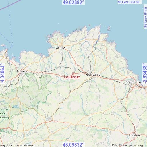
Louargat GPS coordinates[2]
48° 33' 56.736" North, 3° 20' 15" West
| Map corner | latitude | longitude |
|---|---|---|
| Upper-left | 49.02892°, | -4.04063° |
| Center: | 48.56576°, | -3.3375° |
| Lower-right: | 48.09832°, | -2.63438° |
| Map W x H: | 103.5×103.5 km | = 64.3×64.3mi |
| max Lat: | 51.07786° ⇑30.1% North |
| Louargat: | 48.56576° |
| min Lat: | ⇓69.9% South 41.3874° |
| min Long | Louargat | max Long |
| -5.08615° | -3.3375° | 9.52242° |
| W 2%⇐ | ⇒98% E |
Elevation
Elevation of Louargat is 187 m = 614 ft, and this is 6.7 m = 22 ft below average elevation for this country.
| Max E: |
2333 m = 7654 ft | 36.4% |
| Avg. | 193.7 m = 635 ft | |
| Louargat | 187 m = 614 ft | |
Min E: |
-1 m = -3 ft | 63.6% |
See also: France elevation on elevation.city.
Geographical zone
Louargat is located in North temperate zone (between Tropic of Cancer and the Arctic Circle). Distance of this North polar circle is 2001.2 km =1243.5 mi to North.| Distance of | km | miles | from Louargat |
|---|---|---|---|
| North Pole | 4607.1 | 2862.7 | to North |
| Arctic Circle | 2001.2 | 1243.5 | to North |
| Tropic Cancer | 2794.1 | 1736.2 | to South |
| Equator | 5400 | 3355.4 | to South |


Nearby cities:
15 places around Louargat: (largest is in red/bold)
• Belle-Isle-en-Terre
4.8 km =3 mi,  241°
241°
• Bégard
7.4 km =4.6 mi,  21°
21°
• Cavan
11.9 km =7.4 mi,  356°
356°
• Grâces
11.2 km =7 mi,  95°
95°
• Le Vieux-Marché
9.1 km =5.7 mi,  294°
294°
• Loguivy-Plougras
12 km =7.5 mi,  246°
246°
• Moustéru
9 km =5.6 mi,  126°
126°
• Plouaret
11.1 km =6.9 mi,  300°
300°
• Plougonver
9.6 km =6 mi,  198°
198°
• Plouisy
11.4 km =7.1 mi,  83°
83°
• Plounévez-Moëdec
8.3 km =5.2 mi,  270°
270°
• Pluzunet
8.7 km =5.4 mi,  343°
343°
• Pont-Melvez
12 km =7.5 mi,  168°
168°
• Pédernec
6.1 km =3.8 mi,  55°
55°
• Tréglamus
4.8 km =3 mi, 101°
Sources, notices
• [Note1] Compared only with cities in France existing in our database
• [Src1] Map data: © OpenStreetMap contributors (CC-BY-SA)
• [Src2] Other city data from geonames.org with taken over terms of usage.
• [Src3] Geographical zone / Annual Mean Temperature by Robert A. Rohde @ Wikipedia
