Plouisy geodata
Plouisy (Brittany) is a populated place; located in France in Europe/Paris (GMT+2) time zone. With population of 2,053 people, there are 4676 cities with bigger population in this country. Compared to other cities in France, 70.3% of cities are located further ↓South; 97.7% of cities are located further →East and 50.3% of cities have lower elevation than Plouisy. Note1
Administrative division(s):
- Level 1: Brittany
- Level 2: Département des Côtes-d’Armor
- Level 3: Arrondissement de Guingamp
- Level 4: Plouisy


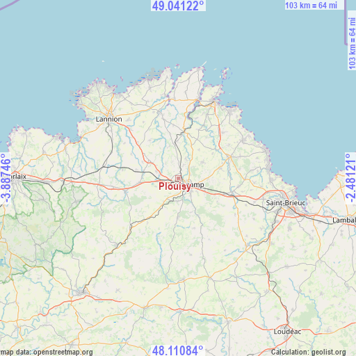
Plouisy GPS coordinates[2]
48° 34' 41.412" North, 3° 11' 3.624" West
| Map corner | latitude | longitude |
|---|---|---|
| Upper-left | 49.04122°, | -3.88746° |
| Center: | 48.57817°, | -3.18434° |
| Lower-right: | 48.11084°, | -2.48121° |
| Map W x H: | 103.4×103.4 km | = 64.2×64.2mi |
| max Lat: | 51.07786° ⇑29.7% North |
| Plouisy: | 48.57817° |
| min Lat: | ⇓70.3% South 41.3874° |
| min Long | Plouisy | max Long |
| -5.08615° | -3.18434° | 9.52242° |
| W 2.3%⇐ | ⇒97.7% E |
Elevation
Elevation of Plouisy is 133 m = 436 ft, and this is 60.7 m = 199 ft below average elevation for this country.
| Max E: |
2333 m = 7654 ft | 49.7% |
| Avg. | 193.7 m = 635 ft | |
| Plouisy | 133 m = 436 ft | |
Min E: |
-1 m = -3 ft | 50.3% |
See also: France elevation on elevation.city.
Geographical zone
Plouisy is located in North temperate zone (between Tropic of Cancer and the Arctic Circle). Distance of this North polar circle is 1999.8 km =1242.6 mi to North.| Distance of | km | miles | from Plouisy |
|---|---|---|---|
| North Pole | 4605.7 | 2861.8 | to North |
| Arctic Circle | 1999.8 | 1242.6 | to North |
| Tropic Cancer | 2795.5 | 1737 | to South |
| Equator | 5401.4 | 3356.3 | to South |


Nearby cities:
15 places around Plouisy: (largest is in red/bold)
• Bégard
10.2 km =6.3 mi,  302°
302°
• Coadout
6.8 km =4.2 mi,  181°
181°
• Grâces
2.4 km =1.5 mi, 181°
• Guingamp
3 km =1.9 mi,  125°
125°
• Le Merzer
8.6 km =5.3 mi,  92°
92°
• Louargat
11.4 km =7.1 mi,  263°
263°
• Moustéru
7.9 km =4.9 mi,  211°
211°
• Pabu
3.7 km =2.3 mi,  76°
76°
• Ploumagoar
5.3 km =3.3 mi, 133°
• Pommerit-le-Vicomte
8.3 km =5.2 mi,  56°
56°
• Pédernec
6.6 km =4.1 mi,  288°
288°
• Saint-Agathon
6.2 km =3.9 mi,  110°
110°
• Saint-Clet
10.4 km =6.5 mi,  21°
21°
• Squiffiec
6 km =3.7 mi, 21°
• Tréglamus
7 km =4.3 mi,  250°
250°
Sources, notices
• [Note1] Compared only with cities in France existing in our database
• [Src1] Map data: © OpenStreetMap contributors (CC-BY-SA)
• [Src2] Other city data from geonames.org with taken over terms of usage.
• [Src3] Geographical zone / Annual Mean Temperature by Robert A. Rohde @ Wikipedia
