Pommérieux geodata
Pommérieux (Grand Est) is a populated place; located in France in Europe/Paris (GMT+2) time zone. With population of 532 people, there are 14567 cities with bigger population in this country. Compared to other cities in France, 79.6% of cities are located further ↓South; 89% of cities are located further ←West and 64.6% of cities have lower elevation than Pommérieux. Note1
Administrative division(s):
- Level 1: Grand Est
- Level 2: Moselle
- Level 3: Arrondissement de Metz
- Level 4: Pommérieux


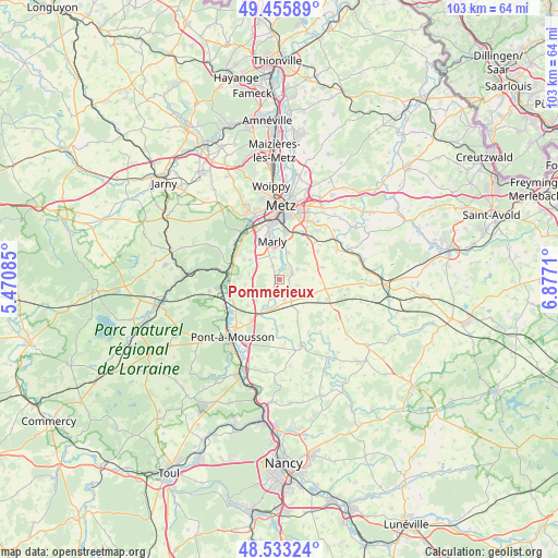
Pommérieux GPS coordinates[2]
48° 59' 48.12" North, 6° 10' 26.328" East
| Map corner | latitude | longitude |
|---|---|---|
| Upper-left | 49.45589°, | 5.47085° |
| Center: | 48.9967°, | 6.17398° |
| Lower-right: | 48.53324°, | 6.8771° |
| Map W x H: | 102.6×102.6 km | = 63.8×63.8mi |
| max Lat: | 51.07786° ⇑20.4% North |
| Pommérieux: | 48.9967° |
| min Lat: | ⇓79.6% South 41.3874° |
| min Long | Pommérieux | max Long |
| -5.08615° | 6.17398° | 9.52242° |
| W 89%⇐ | ⇒11% E |
Elevation
Elevation of Pommérieux is 192 m = 630 ft, and this is 1.7 m = 6 ft below average elevation for this country.
| Max E: |
2333 m = 7654 ft | 35.4% |
| Avg. | 193.7 m = 635 ft | |
| Pommérieux | 192 m = 630 ft | |
Min E: |
-1 m = -3 ft | 64.6% |
See also: France elevation on elevation.city.
Geographical zone
Pommérieux is located in North temperate zone (between Tropic of Cancer and the Arctic Circle). Distance of this North polar circle is 1953.3 km =1213.7 mi to North.| Distance of | km | miles | from Pommérieux |
|---|---|---|---|
| North Pole | 4559.1 | 2832.9 | to North |
| Arctic Circle | 1953.3 | 1213.7 | to North |
| Tropic Cancer | 2842 | 1765.9 | to South |
| Equator | 5447.9 | 3385.2 | to South |


Nearby cities:
15 places around Pommérieux: (largest is in red/bold)
• Augny
8.2 km =5.1 mi,  330°
330°
• Cheminot
6 km =3.7 mi,  205°
205°
• Coin-lès-Cuvry
4.3 km =2.7 mi,  342°
342°
• Corny-sur-Moselle
9.3 km =5.8 mi,  297°
297°
• Cuvry
5.3 km =3.3 mi,  347°
347°
• Fleury
5.2 km =3.2 mi,  15°
15°
• Féy
6.6 km =4.1 mi, 304°
• Lorry
6.4 km =4 mi,  262°
262°
• Louvigny
3.9 km =2.4 mi,  167°
167°
• Marieulles
5.4 km =3.4 mi,  274°
274°
• Marly
7.6 km =4.7 mi, 349°
• Mécleuves
8.8 km =5.5 mi,  53°
53°
• Pouilly
6 km =3.7 mi,  8°
8°
• Pournoy-la-Chétive
2.9 km =1.8 mi, 330°
• Verny
2.4 km =1.5 mi,  62°
62°
Sources, notices
• [Note1] Compared only with cities in France existing in our database
• [Src1] Map data: © OpenStreetMap contributors (CC-BY-SA)
• [Src2] Other city data from geonames.org with taken over terms of usage.
• [Src3] Geographical zone / Annual Mean Temperature by Robert A. Rohde @ Wikipedia
