Chéroy geodata
Chéroy (Bourgogne-Franche-Comté) is a populated place; located in France in Europe/Paris (GMT+2) time zone. With population of 1,462 people, there are 6325 cities with bigger population in this country. Compared to other cities in France, 62.9% of cities are located further ↓South; 57.8% of cities are located further ←West and 55.3% of cities have lower elevation than Chéroy. Note1
Administrative division(s):
- Level 1: Bourgogne-Franche-Comté
- Level 2: Département de l'Yonne
- Level 3: Arrondissement de Sens
- Level 4: Chéroy


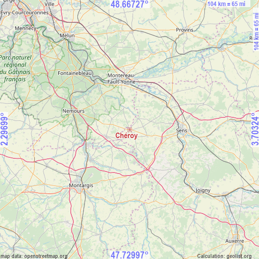
Chéroy GPS coordinates[2]
48° 12' 2.736" North, 3° 0' 0.396" East
| Map corner | latitude | longitude |
|---|---|---|
| Upper-left | 48.66727°, | 2.29699° |
| Center: | 48.20076°, | 3.00011° |
| Lower-right: | 47.72997°, | 3.70324° |
| Map W x H: | 104.2×104.2 km | = 64.7×64.7mi |
| max Lat: | 51.07786° ⇑37.1% North |
| Chéroy: | 48.20076° |
| min Lat: | ⇓62.9% South 41.3874° |
| min Long | Chéroy | max Long |
| -5.08615° | 3.00011° | 9.52242° |
| W 57.8%⇐ | ⇒42.2% E |
Elevation
Elevation of Chéroy is 151 m = 495 ft, and this is 42.7 m = 140 ft below average elevation for this country.
| Max E: |
2333 m = 7654 ft | 44.7% |
| Avg. | 193.7 m = 635 ft | |
| Chéroy | 151 m = 495 ft | |
Min E: |
-1 m = -3 ft | 55.3% |
See also: France elevation on elevation.city.
Geographical zone
Chéroy is located in North temperate zone (between Tropic of Cancer and the Arctic Circle). Distance of this North polar circle is 2041.8 km =1268.7 mi to North.| Distance of | km | miles | from Chéroy |
|---|---|---|---|
| North Pole | 4647.6 | 2887.9 | to North |
| Arctic Circle | 2041.8 | 1268.7 | to North |
| Tropic Cancer | 2753.5 | 1710.9 | to South |
| Equator | 5359.4 | 3330.2 | to South |


Nearby cities:
15 places around Chéroy: (largest is in red/bold)
• Bazoches-sur-le-Betz
7.6 km =4.7 mi,  186°
186°
• Blennes
6.6 km =4.1 mi,  14°
14°
• Brannay
9.3 km =5.8 mi,  69°
69°
• Bransles
13.5 km =8.4 mi,  246°
246°
• Chaintreaux
13.3 km =8.3 mi,  269°
269°
• Domats
10.9 km =6.8 mi,  152°
152°
• Flagy
13.7 km =8.5 mi,  335°
335°
• Lorrez-le-Bocage-Préaux
8.3 km =5.2 mi,  296°
296°
• Montacher-Villegardin
4.5 km =2.8 mi, 146°
• Saint-Valérien
7.5 km =4.7 mi,  109°
109°
• Thoury-Férottes
11.3 km =7 mi, 337°
• Villemaréchal
12.3 km =7.6 mi,  306°
306°
• Villethierry
8.9 km =5.5 mi,  38°
38°
• Voulx
9.4 km =5.8 mi,  345°
345°
• Égreville
9.8 km =6.1 mi, 253°
Sources, notices
• [Note1] Compared only with cities in France existing in our database
• [Src1] Map data: © OpenStreetMap contributors (CC-BY-SA)
• [Src2] Other city data from geonames.org with taken over terms of usage.
• [Src3] Geographical zone / Annual Mean Temperature by Robert A. Rohde @ Wikipedia
