Loperhet geodata
Loperhet (Brittany) is a populated place; located in France in Europe/Paris (GMT+2) time zone. With population of 3,524 people, there are 2763 cities with bigger population in this country. Compared to other cities in France, 65.9% of cities are located further ↓South; 99.5% of cities are located further →East and 68.3% of cities have higher elevation than Loperhet. Note1
Administrative division(s):
- Level 1: Brittany
- Level 2: Département du Finistère
- Level 3: Arrondissement de Brest
- Level 4: Loperhet


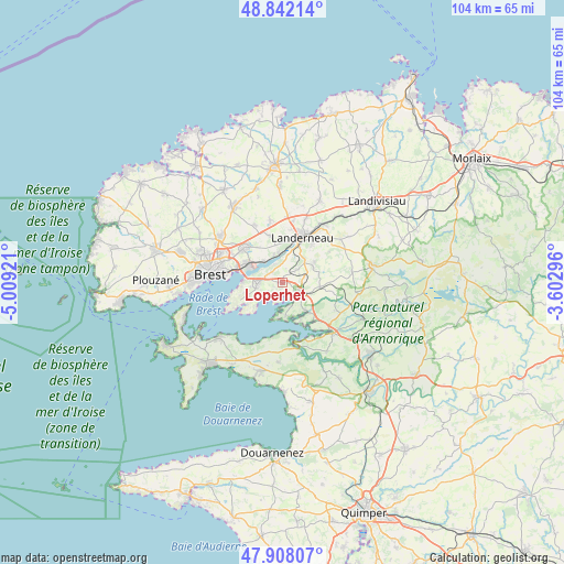
Loperhet GPS coordinates[2]
48° 22' 38.1" North, 4° 18' 21.888" West
| Map corner | latitude | longitude |
|---|---|---|
| Upper-left | 48.84214°, | -5.00921° |
| Center: | 48.37725°, | -4.30608° |
| Lower-right: | 47.90807°, | -3.60296° |
| Map W x H: | 103.9×103.9 km | = 64.6×64.6mi |
| max Lat: | 51.07786° ⇑34.1% North |
| Loperhet: | 48.37725° |
| min Lat: | ⇓65.9% South 41.3874° |
| min Long | Loperhet | max Long |
| -5.08615° | -4.30608° | 9.52242° |
| W 0.5%⇐ | ⇒99.5% E |
Elevation
Elevation of Loperhet is 82 m = 269 ft, and this is 111.7 m = 366 ft below average elevation for this country.
| Max E: |
2333 m = 7654 ft | 68.3% |
| Avg. | 193.7 m = 635 ft | |
| Loperhet | 82 m = 269 ft | |
Min E: |
-1 m = -3 ft | 31.7% |
See also: France elevation on elevation.city.
Geographical zone
Loperhet is located in North temperate zone (between Tropic of Cancer and the Arctic Circle). Distance of this North polar circle is 2022.1 km =1256.5 mi to North.| Distance of | km | miles | from Loperhet |
|---|---|---|---|
| North Pole | 4628 | 2875.7 | to North |
| Arctic Circle | 2022.1 | 1256.5 | to North |
| Tropic Cancer | 2773.1 | 1723.1 | to South |
| Equator | 5379 | 3342.4 | to South |


Nearby cities:
15 places around Loperhet: (largest is in red/bold)
• Daoulas
3.9 km =2.4 mi,  118°
118°
• Dirinon
3.5 km =2.2 mi,  49°
49°
• Guipavas
9.3 km =5.8 mi,  313°
313°
• Hanvec
12.2 km =7.6 mi, 117°
• Hôpital-Camfrout
7.3 km =4.5 mi,  139°
139°
• Irvillac
7 km =4.3 mi,  96°
96°
• Kersaint-Plabennec
11.6 km =7.2 mi,  335°
335°
• La Forest-Landerneau
5.5 km =3.4 mi,  352°
352°
• Landerneau
9.3 km =5.8 mi,  25°
25°
• Le Relecq-Kerhuon
7.3 km =4.5 mi,  297°
297°
• Logonna-Daoulas
6.1 km =3.8 mi,  173°
173°
• Pencran
8.2 km =5.1 mi,  40°
40°
• Plougastel-Daoulas
4.6 km =2.9 mi,  255°
255°
• Saint-Thonan
12 km =7.5 mi, 350°
• Saint-Urbain
5.9 km =3.7 mi,  64°
64°
Sources, notices
• [Note1] Compared only with cities in France existing in our database
• [Src1] Map data: © OpenStreetMap contributors (CC-BY-SA)
• [Src2] Other city data from geonames.org with taken over terms of usage.
• [Src3] Geographical zone / Annual Mean Temperature by Robert A. Rohde @ Wikipedia
