Guipavas geodata
Guipavas (Brittany) is a populated place; located in France in Europe/Paris (GMT+2) time zone. With population of 13,755 people, there are 689 cities with bigger population in this country. Compared to other cities in France, 67% of cities are located further ↓South; 99.7% of cities are located further →East and 67% of cities have higher elevation than Guipavas. Note1
Administrative division(s):
- Level 1: Brittany
- Level 2: Département du Finistère
- Level 3: Arrondissement de Brest
- Level 4: Guipavas


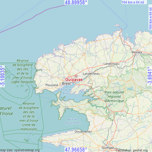
Guipavas GPS coordinates[2]
48° 26' 6.792" North, 4° 23' 49.992" West
| Map corner | latitude | longitude |
|---|---|---|
| Upper-left | 48.89958°, | -5.10035° |
| Center: | 48.43522°, | -4.39722° |
| Lower-right: | 47.96658°, | -3.6941° |
| Map W x H: | 103.7×103.7 km | = 64.4×64.4mi |
| max Lat: | 51.07786° ⇑33% North |
| Guipavas: | 48.43522° |
| min Lat: | ⇓67% South 41.3874° |
| min Long | Guipavas | max Long |
| -5.08615° | -4.39722° | 9.52242° |
| W 0.3%⇐ | ⇒99.7% E |
Elevation
Elevation of Guipavas is 85 m = 279 ft, and this is 108.7 m = 357 ft below average elevation for this country.
| Max E: |
2333 m = 7654 ft | 67% |
| Avg. | 193.7 m = 635 ft | |
| Guipavas | 85 m = 279 ft | |
Min E: |
-1 m = -3 ft | 33% |
See also: France elevation on elevation.city.
Geographical zone
Guipavas is located in North temperate zone (between Tropic of Cancer and the Arctic Circle). Distance of this North polar circle is 2015.7 km =1252.5 mi to North.| Distance of | km | miles | from Guipavas |
|---|---|---|---|
| North Pole | 4621.6 | 2871.7 | to North |
| Arctic Circle | 2015.7 | 1252.5 | to North |
| Tropic Cancer | 2779.6 | 1727.2 | to South |
| Equator | 5385.5 | 3346.4 | to South |


Nearby cities:
15 places around Guipavas: (largest is in red/bold)
• Bohars
8.6 km =5.3 mi,  265°
265°
• Bourg-Blanc
10.6 km =6.6 mi,  311°
311°
• Brest
8.3 km =5.2 mi,  232°
232°
• Dirinon
10.3 km =6.4 mi,  113°
113°
• Gouesnou
5.3 km =3.3 mi,  291°
291°
• Kersaint-Plabennec
4.4 km =2.7 mi,  24°
24°
• La Forest-Landerneau
6.1 km =3.8 mi,  99°
99°
• Landerneau
10.8 km =6.7 mi,  79°
79°
• Le Drennec
11.2 km =7 mi,  10°
10°
• Le Relecq-Kerhuon
3.2 km =2 mi,  175°
175°
• Loperhet
9.3 km =5.8 mi,  133°
133°
• Plabennec
7.8 km =4.8 mi,  343°
343°
• Plougastel-Daoulas
7.9 km =4.9 mi,  163°
163°
• Plouvien
11.6 km =7.2 mi, 340°
• Saint-Thonan
7.1 km =4.4 mi,  41°
41°
Sources, notices
• [Note1] Compared only with cities in France existing in our database
• [Src1] Map data: © OpenStreetMap contributors (CC-BY-SA)
• [Src2] Other city data from geonames.org with taken over terms of usage.
• [Src3] Geographical zone / Annual Mean Temperature by Robert A. Rohde @ Wikipedia
