Logonna-Daoulas geodata
Logonna-Daoulas (Brittany) is a populated place; located in France in Europe/Paris (GMT+2) time zone. With population of 1,659 people, there are 5639 cities with bigger population in this country. Compared to other cities in France, 65% of cities are located further ↓South; 99.5% of cities are located further →East and 83.1% of cities have higher elevation than Logonna-Daoulas. Note1
Administrative division(s):
- Level 1: Brittany
- Level 2: Département du Finistère
- Level 3: Arrondissement de Brest
- Level 4: Logonna-Daoulas


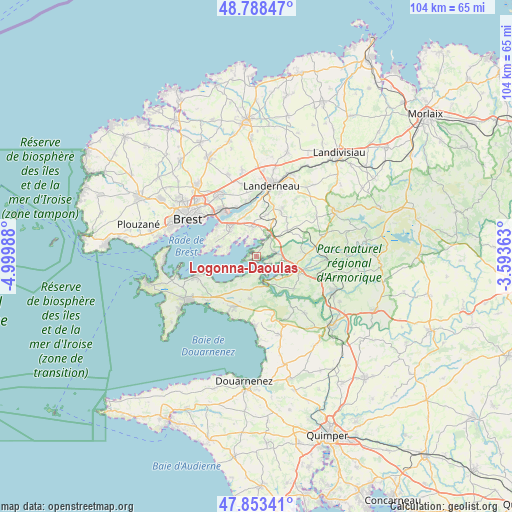
Logonna-Daoulas GPS coordinates[2]
48° 19' 23.088" North, 4° 17' 48.3" West
| Map corner | latitude | longitude |
|---|---|---|
| Upper-left | 48.78847°, | -4.99988° |
| Center: | 48.32308°, | -4.29675° |
| Lower-right: | 47.85341°, | -3.59363° |
| Map W x H: | 104×104 km | = 64.6×64.6mi |
| max Lat: | 51.07786° ⇑35% North |
| Logonna-Daoulas: | 48.32308° |
| min Lat: | ⇓65% South 41.3874° |
| min Long | Logonna-Daoulas | max Long |
| -5.08615° | -4.29675° | 9.52242° |
| W 0.5%⇐ | ⇒99.5% E |
Elevation
Elevation of Logonna-Daoulas is 47 m = 154 ft, and this is 146.7 m = 481 ft below average elevation for this country.
| Max E: |
2333 m = 7654 ft | 83.1% |
| Avg. | 193.7 m = 635 ft | |
| Logonna-Daoulas | 47 m = 154 ft | |
Min E: |
-1 m = -3 ft | 16.9% |
See also: France elevation on elevation.city.
Geographical zone
Logonna-Daoulas is located in North temperate zone (between Tropic of Cancer and the Arctic Circle). Distance of this North polar circle is 2028.2 km =1260.3 mi to North.| Distance of | km | miles | from Logonna-Daoulas |
|---|---|---|---|
| North Pole | 4634 | 2879.4 | to North |
| Arctic Circle | 2028.2 | 1260.3 | to North |
| Tropic Cancer | 2767.1 | 1719.4 | to South |
| Equator | 5373 | 3338.6 | to South |


Nearby cities:
15 places around Logonna-Daoulas: (largest is in red/bold)
• Argol
8.7 km =5.4 mi,  189°
189°
• Daoulas
5 km =3.1 mi,  33°
33°
• Dirinon
8.5 km =5.3 mi,  13°
13°
• Hanvec
10.2 km =6.3 mi,  87°
87°
• Hôpital-Camfrout
4.1 km =2.5 mi,  82°
82°
• Irvillac
8.1 km =5 mi,  50°
50°
• La Forest-Landerneau
11.5 km =7.1 mi,  352°
352°
• Lanvéoc
12.9 km =8 mi,  252°
252°
• Le Faou
9.2 km =5.7 mi,  110°
110°
• Le Relecq-Kerhuon
11.7 km =7.3 mi,  322°
322°
• Loperhet
6.1 km =3.8 mi, 353°
• Plougastel-Daoulas
7.1 km =4.4 mi,  313°
313°
• Rosnoën
9.5 km =5.9 mi,  131°
131°
• Saint-Urbain
9.8 km =6.1 mi, 28°
• Telgruc-sur-Mer
10.7 km =6.6 mi,  201°
201°
Sources, notices
• [Note1] Compared only with cities in France existing in our database
• [Src1] Map data: © OpenStreetMap contributors (CC-BY-SA)
• [Src2] Other city data from geonames.org with taken over terms of usage.
• [Src3] Geographical zone / Annual Mean Temperature by Robert A. Rohde @ Wikipedia
