Wissous geodata
Wissous (Île-de-France) is a populated place; located in France in Europe/Paris (GMT+2) time zone. With population of 4,765 people, there are 2083 cities with bigger population in this country. Compared to other cities in France, 74% of cities are located further ↓South; 52.3% of cities are located further →East and 70.1% of cities have higher elevation than Wissous. Note1
Administrative division(s):
- Level 1: Île-de-France
- Level 2: Département de l'Essonne
- Level 3: Arrondissement de Palaiseau
- Level 4: Wissous


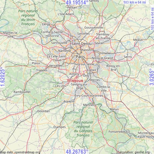
Wissous GPS coordinates[2]
48° 44' 0.672" North, 2° 19' 24.168" East
| Map corner | latitude | longitude |
|---|---|---|
| Upper-left | 49.19514°, | 1.62025° |
| Center: | 48.73352°, | 2.32338° |
| Lower-right: | 48.26763°, | 3.0265° |
| Map W x H: | 103.1×103.1 km | = 64.1×64.1mi |
| max Lat: | 51.07786° ⇑26% North |
| Wissous: | 48.73352° |
| min Lat: | ⇓74% South 41.3874° |
| min Long | Wissous | max Long |
| -5.08615° | 2.32338° | 9.52242° |
| W 47.7%⇐ | ⇒52.3% E |
Elevation
Elevation of Wissous is 78 m = 256 ft, and this is 115.7 m = 380 ft below average elevation for this country.
| Max E: |
2333 m = 7654 ft | 70.1% |
| Avg. | 193.7 m = 635 ft | |
| Wissous | 78 m = 256 ft | |
Min E: |
-1 m = -3 ft | 29.9% |
See also: France elevation on elevation.city.
Geographical zone
Wissous is located in North temperate zone (between Tropic of Cancer and the Arctic Circle). Distance of this North polar circle is 1982.5 km =1231.9 mi to North.| Distance of | km | miles | from Wissous |
|---|---|---|---|
| North Pole | 4588.4 | 2851.1 | to North |
| Arctic Circle | 1982.5 | 1231.9 | to North |
| Tropic Cancer | 2812.7 | 1747.7 | to South |
| Equator | 5418.7 | 3367 | to South |


Nearby cities:
15 places around Wissous: (largest is in red/bold)
• Antony
2.9 km =1.8 mi,  318°
318°
• Bourg-la-Reine
5.1 km =3.2 mi,  355°
355°
• Champlan
4.3 km =2.7 mi,  228°
228°
• Chevilly-Larue
4 km =2.5 mi,  29°
29°
• Chilly-Mazarin
2.1 km =1.3 mi,  193°
193°
• Châtenay-Malabry
5.4 km =3.4 mi,  310°
310°
• Fresnes
2.5 km =1.6 mi, 358°
• Longjumeau
4.4 km =2.7 mi,  195°
195°
• Massy
3.1 km =1.9 mi,  256°
256°
• Morangis
3.5 km =2.2 mi,  160°
160°
• Orly
5.3 km =3.3 mi,  72°
72°
• Paray-Vieille-Poste
3.6 km =2.2 mi,  126°
126°
• Rungis
2.6 km =1.6 mi,  57°
57°
• Sceaux
5.4 km =3.4 mi,  333°
333°
• Verrières-le-Buisson
4.3 km =2.7 mi,  288°
288°
Sources, notices
• [Note1] Compared only with cities in France existing in our database
• [Src1] Map data: © OpenStreetMap contributors (CC-BY-SA)
• [Src2] Other city data from geonames.org with taken over terms of usage.
• [Src3] Geographical zone / Annual Mean Temperature by Robert A. Rohde @ Wikipedia
