Massy geodata
Massy (Île-de-France) is a populated place; located in France in Europe/Paris (GMT+2) time zone. With population of 38,768 people, there are 192 cities with bigger population in this country. Compared to other cities in France, 73.8% of cities are located further ↓South; 53% of cities are located further →East and 67.4% of cities have higher elevation than Massy. Note1
Administrative division(s):
- Level 1: Île-de-France
- Level 2: Département de l'Essonne
- Level 3: Arrondissement de Palaiseau
- Level 4: Massy


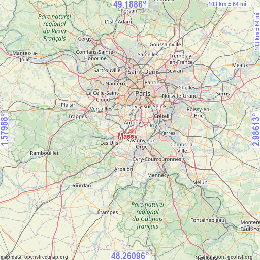
Massy GPS coordinates[2]
48° 43' 36.912" North, 2° 16' 58.836" East
| Map corner | latitude | longitude |
|---|---|---|
| Upper-left | 49.1886°, | 1.57988° |
| Center: | 48.72692°, | 2.28301° |
| Lower-right: | 48.26096°, | 2.98613° |
| Map W x H: | 103.1×103.1 km | = 64.1×64.1mi |
| max Lat: | 51.07786° ⇑26.2% North |
| Massy: | 48.72692° |
| min Lat: | ⇓73.8% South 41.3874° |
| min Long | Massy | max Long |
| -5.08615° | 2.28301° | 9.52242° |
| W 47%⇐ | ⇒53% E |
Elevation
Elevation of Massy is 84 m = 276 ft, and this is 109.7 m = 360 ft below average elevation for this country.
| Max E: |
2333 m = 7654 ft | 67.4% |
| Avg. | 193.7 m = 635 ft | |
| Massy | 84 m = 276 ft | |
Min E: |
-1 m = -3 ft | 32.6% |
See also: France elevation on elevation.city.
Geographical zone
Massy is located in North temperate zone (between Tropic of Cancer and the Arctic Circle). Distance of this North polar circle is 1983.2 km =1232.3 mi to North.| Distance of | km | miles | from Massy |
|---|---|---|---|
| North Pole | 4589.1 | 2851.5 | to North |
| Arctic Circle | 1983.2 | 1232.3 | to North |
| Tropic Cancer | 2812 | 1747.3 | to South |
| Equator | 5417.9 | 3366.5 | to South |


Nearby cities:
15 places around Massy: (largest is in red/bold)
• Antony
3.1 km =1.9 mi,  18°
18°
• Champlan
2.1 km =1.3 mi,  186°
186°
• Chilly-Mazarin
2.8 km =1.7 mi,  118°
118°
• Châtenay-Malabry
4.4 km =2.7 mi,  344°
344°
• Fresnes
4.3 km =2.7 mi,  42°
42°
• Igny
4.7 km =2.9 mi,  294°
294°
• Longjumeau
4 km =2.5 mi,  153°
153°
• Morangis
4.8 km =3 mi, 121°
• Palaiseau
2.6 km =1.6 mi,  248°
248°
• Rungis
5.5 km =3.4 mi,  67°
67°
• Saulx-les-Chartreux
4.2 km =2.6 mi,  195°
195°
• Sceaux
5.5 km =3.4 mi,  5°
5°
• Verrières-le-Buisson
2.4 km =1.5 mi,  332°
332°
• Villebon-sur-Yvette
3.9 km =2.4 mi,  233°
233°
• Wissous
3.1 km =1.9 mi,  76°
76°
Sources, notices
• [Note1] Compared only with cities in France existing in our database
• [Src1] Map data: © OpenStreetMap contributors (CC-BY-SA)
• [Src2] Other city data from geonames.org with taken over terms of usage.
• [Src3] Geographical zone / Annual Mean Temperature by Robert A. Rohde @ Wikipedia
