Rieux geodata
Rieux (Normandy) is a populated place; located in France in Europe/Paris (GMT+2) time zone. With population of 653 people, there are 12485 cities with bigger population in this country. Compared to other cities in France, 93.2% of cities are located further ↓South; 62% of cities are located further →East and 73.6% of cities have higher elevation than Rieux. Note1
Administrative division(s):
- Level 1: Normandy
- Level 2: Seine-Maritime
- Level 3: Arrondissement de Dieppe
- Level 4: Rieux


Rieux GPS coordinates[2]
49° 56' 8.808" North, 1° 34' 55.164" East
| Map corner | latitude | longitude |
|---|---|---|
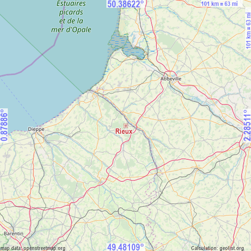
| Upper-left | 50.38622°, | 0.87886° |
| Center: | 49.93578°, | 1.58199° |
| Lower-right: | 49.48109°, | 2.28511° |
| Map W x H: | 100.6×100.6 km | = 62.5×62.5mi |
| max Lat: | 51.07786° ⇑6.8% North |
| Rieux: | 49.93578° |
| min Lat: | ⇓93.2% South 41.3874° |
| min Long | Rieux | max Long |
| -5.08615° | 1.58199° | 9.52242° |
| W 38%⇐ | ⇒62% E |
Elevation
Elevation of Rieux is 70 m = 230 ft, and this is 123.7 m = 406 ft below average elevation for this country.
| Max E: |
2333 m = 7654 ft | 73.6% |
| Avg. | 193.7 m = 635 ft | |
| Rieux | 70 m = 230 ft | |
Min E: |
-1 m = -3 ft | 26.4% |
See also: France elevation on elevation.city.
Geographical zone
Rieux is located in North temperate zone (between Tropic of Cancer and the Arctic Circle). Distance of this North polar circle is 1848.8 km =1148.8 mi to North.| Distance of | km | miles | from Rieux |
|---|---|---|---|
| North Pole | 4454.7 | 2768 | to North |
| Arctic Circle | 1848.8 | 1148.8 | to North |
| Tropic Cancer | 2946.4 | 1830.8 | to South |
| Equator | 5552.3 | 3450 | to South |


Nearby cities:
15 places around Rieux: (largest is in red/bold)
• Aigneville
11.3 km =7 mi,  14°
14°
• Beauchamps
9.6 km =6 mi,  331°
331°
• Blangy-sur-Bresle
3.1 km =1.9 mi,  97°
97°
• Bouttencourt
3.7 km =2.3 mi,  87°
87°
• Bouvaincourt-sur-Bresle
12.3 km =7.6 mi, 328°
• Embreville
10.7 km =6.6 mi,  344°
344°
• Foucarmont
9.9 km =6.2 mi,  185°
185°
• Fresnoy-Folny
12.2 km =7.6 mi,  244°
244°
• Gamaches
5.9 km =3.7 mi, 341°
• Incheville
10.6 km =6.6 mi,  323°
323°
• Longroy
6.6 km =4.1 mi, 332°
• Maisnières
9.2 km =5.7 mi,  16°
16°
• Monchaux-Soreng
1.7 km =1.1 mi,  30°
30°
• Monchy-sur-Eu
11.3 km =7 mi,  305°
305°
• Senarpont
11.2 km =7 mi,  118°
118°
Sources, notices
• [Note1] Compared only with cities in France existing in our database
• [Src1] Map data: © OpenStreetMap contributors (CC-BY-SA)
• [Src2] Other city data from geonames.org with taken over terms of usage.
• [Src3] Geographical zone / Annual Mean Temperature by Robert A. Rohde @ Wikipedia
