Lognes geodata
Lognes (Île-de-France) is a populated place; located in France in Europe/Paris (GMT+2) time zone. With population of 15,519 people, there are 622 cities with bigger population in this country. Compared to other cities in France, 76.3% of cities are located further ↓South; 52.5% of cities are located further ←West and 64% of cities have higher elevation than Lognes. Note1
Administrative division(s):
- Level 1: Île-de-France
- Level 2: Seine-et-Marne
- Level 3: Arrondissement de Torcy
- Level 4: Lognes


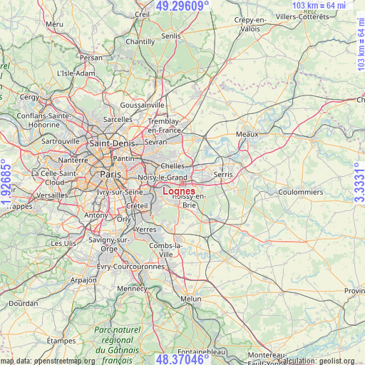
Lognes GPS coordinates[2]
48° 50' 7.476" North, 2° 37' 47.928" East
| Map corner | latitude | longitude |
|---|---|---|
| Upper-left | 49.29609°, | 1.92685° |
| Center: | 48.83541°, | 2.62998° |
| Lower-right: | 48.37046°, | 3.3331° |
| Map W x H: | 102.9×102.9 km | = 63.9×63.9mi |
| max Lat: | 51.07786° ⇑23.7% North |
| Lognes: | 48.83541° |
| min Lat: | ⇓76.3% South 41.3874° |
| min Long | Lognes | max Long |
| -5.08615° | 2.62998° | 9.52242° |
| W 52.5%⇐ | ⇒47.5% E |
Elevation
Elevation of Lognes is 92 m = 302 ft, and this is 101.7 m = 334 ft below average elevation for this country.
| Max E: |
2333 m = 7654 ft | 64% |
| Avg. | 193.7 m = 635 ft | |
| Lognes | 92 m = 302 ft | |
Min E: |
-1 m = -3 ft | 36% |
See also: France elevation on elevation.city.
Geographical zone
Lognes is located in North temperate zone (between Tropic of Cancer and the Arctic Circle). Distance of this North polar circle is 1971.2 km =1224.8 mi to North.| Distance of | km | miles | from Lognes |
|---|---|---|---|
| North Pole | 4577.1 | 2844.1 | to North |
| Arctic Circle | 1971.2 | 1224.8 | to North |
| Tropic Cancer | 2824.1 | 1754.8 | to South |
| Equator | 5430 | 3374 | to South |


Nearby cities:
15 places around Lognes: (largest is in red/bold)
• Brou-sur-Chantereine
5.3 km =3.3 mi,  2°
2°
• Bussy-Saint-Martin
4.7 km =2.9 mi,  71°
71°
• Champs-sur-Marne
2.7 km =1.7 mi,  306°
306°
• Collégien
3.2 km =2 mi,  89°
89°
• Croissy-Beaubourg
3 km =1.9 mi,  105°
105°
• Gournay-sur-Marne
4.5 km =2.8 mi, 311°
• Gouvernes
5.2 km =3.2 mi,  58°
58°
• Le Plessis-Trévise
5 km =3.1 mi,  236°
236°
• Noisiel
1.5 km =0.9 mi,  344°
344°
• Noisy-le-Grand
5.2 km =3.2 mi,  287°
287°
• Pontault-Combault
4.5 km =2.8 mi,  202°
202°
• Roissy-en-Brie
5 km =3.1 mi,  165°
165°
• Torcy
2.3 km =1.4 mi,  41°
41°
• Vaires-sur-Marne
4.6 km =2.9 mi,  8°
8°
• Émerainville
2.6 km =1.6 mi,  194°
194°
Sources, notices
• [Note1] Compared only with cities in France existing in our database
• [Src1] Map data: © OpenStreetMap contributors (CC-BY-SA)
• [Src2] Other city data from geonames.org with taken over terms of usage.
• [Src3] Geographical zone / Annual Mean Temperature by Robert A. Rohde @ Wikipedia
