Le Plessis-Trévise geodata
Le Plessis-Trévise (Île-de-France) is a populated place; located in France in Europe/Paris (GMT+2) time zone. With population of 18,618 people, there are 503 cities with bigger population in this country. Compared to other cities in France, 75.7% of cities are located further ↓South; 51.8% of cities are located further ←West and 59.1% of cities have higher elevation than Le Plessis-Trévise. Note1
Administrative division(s):
- Level 1: Île-de-France
- Level 2: Val-de-Marne
- Level 3: Arrondissement de Créteil
- Level 4: Le Plessis-Trévise


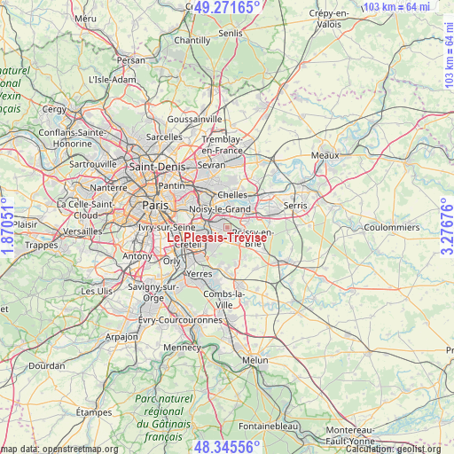
Le Plessis-Trévise GPS coordinates[2]
48° 48' 38.664" North, 2° 34' 25.068" East
| Map corner | latitude | longitude |
|---|---|---|
| Upper-left | 49.27165°, | 1.87051° |
| Center: | 48.81074°, | 2.57363° |
| Lower-right: | 48.34556°, | 3.27676° |
| Map W x H: | 103×103 km | = 64×64mi |
| max Lat: | 51.07786° ⇑24.3% North |
| Le Plessis-Trévise: | 48.81074° |
| min Lat: | ⇓75.7% South 41.3874° |
| min Long | Le Plessis-Tré | max Long |
| -5.08615° | 2.57363° | 9.52242° |
| W 51.8%⇐ | ⇒48.2% E |
Elevation
Elevation of Le Plessis-Trévise is 105 m = 344 ft, and this is 88.7 m = 291 ft below average elevation for this country.
| Max E: |
2333 m = 7654 ft | 59.1% |
| Avg. | 193.7 m = 635 ft | |
| Le Plessis-Trévise | 105 m = 344 ft | |
Min E: |
-1 m = -3 ft | 40.9% |
See also: France elevation on elevation.city.
Geographical zone
Le Plessis-Trévise is located in North temperate zone (between Tropic of Cancer and the Arctic Circle). Distance of this North polar circle is 1973.9 km =1226.5 mi to North.| Distance of | km | miles | from Le Plessis-Trévise |
|---|---|---|---|
| North Pole | 4579.8 | 2845.8 | to North |
| Arctic Circle | 1973.9 | 1226.5 | to North |
| Tropic Cancer | 2821.3 | 1753.1 | to South |
| Equator | 5427.2 | 3372.3 | to South |


Nearby cities:
15 places around Le Plessis-Trévise: (largest is in red/bold)
• Bry-sur-Marne
4.7 km =2.9 mi,  310°
310°
• Champs-sur-Marne
4.8 km =3 mi,  23°
23°
• Chennevières-sur-Marne
2.9 km =1.8 mi,  237°
237°
• Gournay-sur-Marne
5.8 km =3.6 mi,  7°
7°
• La Queue-en-Brie
2.9 km =1.8 mi,  169°
169°
• Lognes
5 km =3.1 mi,  56°
56°
• Neuilly-sur-Marne
5.1 km =3.2 mi,  339°
339°
• Noiseau
4.3 km =2.7 mi,  205°
205°
• Noisiel
5.6 km =3.5 mi,  41°
41°
• Noisy-le-Grand
4.4 km =2.7 mi,  349°
349°
• Ormesson-sur-Marne
3.4 km =2.1 mi,  217°
217°
• Pontault-Combault
2.8 km =1.7 mi,  120°
120°
• Sucy-en-Brie
5.5 km =3.4 mi, 211°
• Villiers-sur-Marne
2.9 km =1.8 mi,  320°
320°
• Émerainville
3.5 km =2.2 mi,  86°
86°
Sources, notices
• [Note1] Compared only with cities in France existing in our database
• [Src1] Map data: © OpenStreetMap contributors (CC-BY-SA)
• [Src2] Other city data from geonames.org with taken over terms of usage.
• [Src3] Geographical zone / Annual Mean Temperature by Robert A. Rohde @ Wikipedia
