Noisy-le-Grand geodata
Noisy-le-Grand (Île-de-France) is a populated place; located in France in Europe/Paris (GMT+2) time zone. With population of 62,420 people, there are 75 cities with bigger population in this country. Compared to other cities in France, 76.6% of cities are located further ↓South; 51.6% of cities are located further ←West and 68.7% of cities have higher elevation than Noisy-le-Grand. Note1
Administrative division(s):
- Level 1: Île-de-France
- Level 2: Seine-Saint-Denis
- Level 3: Arrondissement du Raincy
- Level 4: Noisy-le-Grand


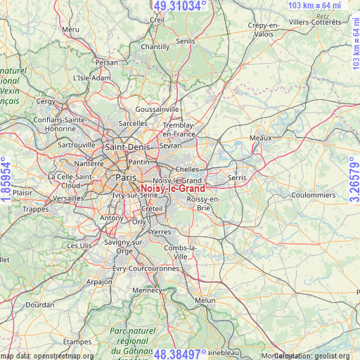
Noisy-le-Grand GPS coordinates[2]
48° 50' 59.244" North, 2° 33' 45.576" East
| Map corner | latitude | longitude |
|---|---|---|
| Upper-left | 49.31034°, | 1.85954° |
| Center: | 48.84979°, | 2.56266° |
| Lower-right: | 48.38497°, | 3.26579° |
| Map W x H: | 102.9×102.9 km | = 63.9×63.9mi |
| max Lat: | 51.07786° ⇑23.4% North |
| Noisy-le-Grand: | 48.84979° |
| min Lat: | ⇓76.6% South 41.3874° |
| min Long | Noisy-le-Grand | max Long |
| -5.08615° | 2.56266° | 9.52242° |
| W 51.6%⇐ | ⇒48.4% E |
Elevation
Elevation of Noisy-le-Grand is 81 m = 266 ft, and this is 112.7 m = 370 ft below average elevation for this country.
| Max E: |
2333 m = 7654 ft | 68.7% |
| Avg. | 193.7 m = 635 ft | |
| Noisy-le-Grand | 81 m = 266 ft | |
Min E: |
-1 m = -3 ft | 31.3% |
See also: Noisy-le-Grand elevation on elevation.city.
Geographical zone
Noisy-le-Grand is located in North temperate zone (between Tropic of Cancer and the Arctic Circle). Distance of this North polar circle is 1969.6 km =1223.9 mi to North.| Distance of | km | miles | from Noisy-le-Grand |
|---|---|---|---|
| North Pole | 4575.5 | 2843.1 | to North |
| Arctic Circle | 1969.6 | 1223.9 | to North |
| Tropic Cancer | 2825.7 | 1755.8 | to South |
| Equator | 5431.6 | 3375 | to South |


Nearby cities:
15 places around Noisy-le-Grand: (largest is in red/bold)
• Bry-sur-Marne
3.1 km =1.9 mi,  244°
244°
• Champs-sur-Marne
2.7 km =1.7 mi,  89°
89°
• Chelles
4.1 km =2.5 mi,  32°
32°
• Fontenay-sous-Bois
5.9 km =3.7 mi,  275°
275°
• Gagny
4.3 km =2.7 mi,  330°
330°
• Gournay-sur-Marne
2.1 km =1.3 mi,  49°
49°
• Le Perreux-sur-Marne
4.6 km =2.9 mi,  270°
270°
• Le Plessis-Trévise
4.4 km =2.7 mi,  169°
169°
• Lognes
5.2 km =3.2 mi,  107°
107°
• Montfermeil
5.5 km =3.4 mi,  12°
12°
• Neuilly-Plaisance
4.4 km =2.7 mi,  290°
290°
• Neuilly-sur-Marne
1.1 km =0.7 mi, 293°
• Noisiel
4.5 km =2.8 mi, 91°
• Rosny-sous-Bois
5.2 km =3.2 mi,  295°
295°
• Villiers-sur-Marne
2.3 km =1.4 mi,  206°
206°
Sources, notices
• [Note1] Compared only with cities in France existing in our database
• [Src1] Map data: © OpenStreetMap contributors (CC-BY-SA)
• [Src2] Other city data from geonames.org with taken over terms of usage.
• [Src3] Geographical zone / Annual Mean Temperature by Robert A. Rohde @ Wikipedia
