Limons geodata
Limons (Auvergne-Rhône-Alpes) is a populated place; located in France in Europe/Paris (GMT+2) time zone. With population of 659 people, there are 12396 cities with bigger population in this country. Compared to other cities in France, 66.6% of cities are located further ↑North; 63.7% of cities are located further ←West and 78% of cities have lower elevation than Limons. Note1
Administrative division(s):
- Level 1: Auvergne-Rhône-Alpes
- Level 2: Département du Puy-de-Dôme
- Level 3: Arrondissement de Riom
- Level 4: Limons


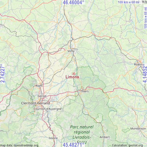
Limons GPS coordinates[2]
45° 58' 24.708" North, 3° 26' 43.404" East
| Map corner | latitude | longitude |
|---|---|---|
| Upper-left | 46.46004°, | 2.74227° |
| Center: | 45.97353°, | 3.44539° |
| Lower-right: | 45.48271°, | 4.14852° |
| Map W x H: | 108.7×108.7 km | = 67.5×67.5mi |
| max Lat: | 51.07786° ⇑66.6% North |
| Limons: | 45.97353° |
| min Lat: | ⇓33.4% South 41.3874° |
| min Long | Limons | max Long |
| -5.08615° | 3.44539° | 9.52242° |
| W 63.7%⇐ | ⇒36.3% E |
Elevation
Elevation of Limons is 272 m = 892 ft, and this is 78.3 m = 257 ft above average elevation for this country.
| Max E: |
2333 m = 7654 ft | 22% |
| Limons | 272 m 892 ft | |
| Avg. | 193.7 m = 635 ft | |
Min E: |
-1 m = -3 ft | 78% |
See also: France elevation on elevation.city.
Geographical zone
Limons is located in North temperate zone (between Tropic of Cancer and the Arctic Circle). Distance of this North polar circle is 2289.4 km =1422.6 mi to North.| Distance of | km | miles | from Limons |
|---|---|---|---|
| North Pole | 4895.3 | 3041.8 | to North |
| Arctic Circle | 2289.4 | 1422.6 | to North |
| Tropic Cancer | 2505.9 | 1557.1 | to South |
| Equator | 5111.8 | 3176.3 | to South |


Nearby cities:
15 places around Limons: (largest is in red/bold)
• Busset
11.1 km =6.9 mi,  27°
27°
• Châteldon
5.8 km =3.6 mi,  86°
86°
• Crevant-Laveine
8.5 km =5.3 mi,  219°
219°
• Dorat
9.4 km =5.8 mi,  162°
162°
• Luzillat
5.2 km =3.2 mi,  234°
234°
• Maringues
10.6 km =6.6 mi,  237°
237°
• Mariol
6.6 km =4.1 mi,  37°
37°
• Orléat
12.7 km =7.9 mi,  188°
188°
• Paslières
6.4 km =4 mi,  141°
141°
• Pragoulin
9.8 km =6.1 mi,  335°
335°
• Puy-Guillaume
2.7 km =1.7 mi,  123°
123°
• Randan
8.5 km =5.3 mi,  305°
305°
• Ris
5.5 km =3.4 mi,  58°
58°
• Saint-Priest-Bramefant
6.2 km =3.9 mi,  356°
356°
• Saint-Yorre
10.4 km =6.5 mi,  8°
8°
Sources, notices
• [Note1] Compared only with cities in France existing in our database
• [Src1] Map data: © OpenStreetMap contributors (CC-BY-SA)
• [Src2] Other city data from geonames.org with taken over terms of usage.
• [Src3] Geographical zone / Annual Mean Temperature by Robert A. Rohde @ Wikipedia
