Paslières geodata
Paslières (Auvergne-Rhône-Alpes) is a populated place; located in France in Europe/Paris (GMT+2) time zone. With population of 1,431 people, there are 6477 cities with bigger population in this country. Compared to other cities in France, 67.2% of cities are located further ↑North; 64.2% of cities are located further ←West and 87.9% of cities have lower elevation than Paslières. Note1
Administrative division(s):
- Level 1: Auvergne-Rhône-Alpes
- Level 2: Département du Puy-de-Dôme
- Level 3: Arrondissement de Thiers
- Level 4: Paslières


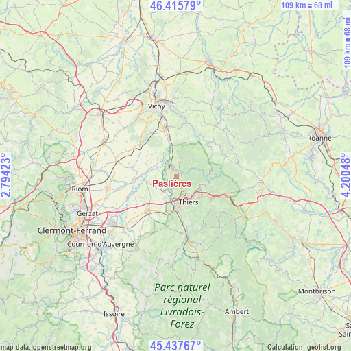
Paslières GPS coordinates[2]
45° 55' 44.004" North, 3° 29' 50.496" East
| Map corner | latitude | longitude |
|---|---|---|
| Upper-left | 46.41579°, | 2.79423° |
| Center: | 45.92889°, | 3.49736° |
| Lower-right: | 45.43767°, | 4.20048° |
| Map W x H: | 108.8×108.8 km | = 67.6×67.6mi |
| max Lat: | 51.07786° ⇑67.2% North |
| Paslières: | 45.92889° |
| min Lat: | ⇓32.8% South 41.3874° |
| min Long | Paslières | max Long |
| -5.08615° | 3.49736° | 9.52242° |
| W 64.2%⇐ | ⇒35.8% E |
Elevation
Elevation of Paslières is 388 m = 1273 ft, and this is 194.3 m = 637 ft above average elevation for this country.
| Max E: |
2333 m = 7654 ft | 12.1% |
| Paslières | 388 m 1273 ft | |
| Avg. | 193.7 m = 635 ft | |
Min E: |
-1 m = -3 ft | 87.9% |
See also: France elevation on elevation.city.
Geographical zone
Paslières is located in North temperate zone (between Tropic of Cancer and the Arctic Circle). Distance of this North polar circle is 2294.4 km =1425.7 mi to North.| Distance of | km | miles | from Paslières |
|---|---|---|---|
| North Pole | 4900.2 | 3044.8 | to North |
| Arctic Circle | 2294.4 | 1425.7 | to North |
| Tropic Cancer | 2500.9 | 1554 | to South |
| Equator | 5106.8 | 3173.2 | to South |


Nearby cities:
15 places around Paslières: (largest is in red/bold)
• Châteldon
5.6 km =3.5 mi,  18°
18°
• Crevant-Laveine
9.6 km =6 mi,  260°
260°
• Dorat
4.2 km =2.6 mi,  197°
197°
• La Monnerie-le-Montel
10.3 km =6.4 mi,  128°
128°
• Limons
6.4 km =4 mi,  321°
321°
• Luzillat
8.5 km =5.3 mi,  283°
283°
• Mariol
10.2 km =6.3 mi,  359°
359°
• Orléat
9.6 km =6 mi,  217°
217°
• Palladuc
10.5 km =6.5 mi,  104°
104°
• Peschadoires
11.4 km =7.1 mi,  181°
181°
• Puy-Guillaume
3.9 km =2.4 mi,  332°
332°
• Ris
7.8 km =4.8 mi,  4°
4°
• Saint-Priest-Bramefant
11.9 km =7.4 mi,  338°
338°
• Saint-Rémy-sur-Durolle
8.6 km =5.3 mi,  121°
121°
• Thiers
8.9 km =5.5 mi,  154°
154°
Sources, notices
• [Note1] Compared only with cities in France existing in our database
• [Src1] Map data: © OpenStreetMap contributors (CC-BY-SA)
• [Src2] Other city data from geonames.org with taken over terms of usage.
• [Src3] Geographical zone / Annual Mean Temperature by Robert A. Rohde @ Wikipedia
