Busset geodata
Busset (Auvergne-Rhône-Alpes) is a populated place; located in France in Europe/Paris (GMT+2) time zone. With population of 878 people, there are 9833 cities with bigger population in this country. Compared to other cities in France, 65.6% of cities are located further ↑North; 64.3% of cities are located further ←West and 92.3% of cities have lower elevation than Busset. Note1
Administrative division(s):
- Level 1: Auvergne-Rhône-Alpes
- Level 2: Département de l'Allier
- Level 3: Arrondissement de Vichy
- Level 4: Busset


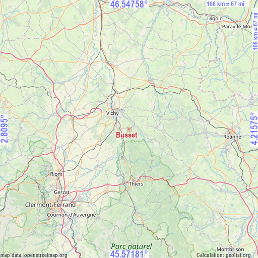
Busset GPS coordinates[2]
46° 3' 42.66" North, 3° 30' 45.432" East
| Map corner | latitude | longitude |
|---|---|---|
| Upper-left | 46.54758°, | 2.8095° |
| Center: | 46.06185°, | 3.51262° |
| Lower-right: | 45.57181°, | 4.21575° |
| Map W x H: | 108.5×108.5 km | = 67.4×67.4mi |
| max Lat: | 51.07786° ⇑65.6% North |
| Busset: | 46.06185° |
| min Lat: | ⇓34.4% South 41.3874° |
| min Long | Busset | max Long |
| -5.08615° | 3.51262° | 9.52242° |
| W 64.3%⇐ | ⇒35.7% E |
Elevation
Elevation of Busset is 485 m = 1591 ft, and this is 291.3 m = 956 ft above average elevation for this country.
| Max E: |
2333 m = 7654 ft | 7.7% |
| Busset | 485 m 1591 ft | |
| Avg. | 193.7 m = 635 ft | |
Min E: |
-1 m = -3 ft | 92.3% |
See also: France elevation on elevation.city.
Geographical zone
Busset is located in North temperate zone (between Tropic of Cancer and the Arctic Circle). Distance of this North polar circle is 2279.6 km =1416.5 mi to North.| Distance of | km | miles | from Busset |
|---|---|---|---|
| North Pole | 4885.5 | 3035.7 | to North |
| Arctic Circle | 2279.6 | 1416.5 | to North |
| Tropic Cancer | 2515.7 | 1563.2 | to South |
| Equator | 5121.6 | 3182.4 | to South |


Nearby cities:
15 places around Busset: (largest is in red/bold)
• Abrest
6.6 km =4.1 mi,  307°
307°
• Bellerive-sur-Allier
10.3 km =6.4 mi, 305°
• Brugheas
11.3 km =7 mi,  278°
278°
• Châteldon
9.5 km =5.9 mi,  176°
176°
• Cusset
9.2 km =5.7 mi,  331°
331°
• Ferrières-sur-Sichon
11.3 km =7 mi,  111°
111°
• Hauterive
5.9 km =3.7 mi,  299°
299°
• Limons
11.1 km =6.9 mi,  207°
207°
• Mariol
4.7 km =2.9 mi,  194°
194°
• Molles
6.6 km =4.1 mi,  32°
32°
• Pragoulin
9.2 km =5.7 mi,  264°
264°
• Ris
7 km =4.3 mi, 184°
• Saint-Priest-Bramefant
6.6 km =4.1 mi,  236°
236°
• Saint-Yorre
3.8 km =2.4 mi, 277°
• Vichy
9.9 km =6.2 mi,  317°
317°
Sources, notices
• [Note1] Compared only with cities in France existing in our database
• [Src1] Map data: © OpenStreetMap contributors (CC-BY-SA)
• [Src2] Other city data from geonames.org with taken over terms of usage.
• [Src3] Geographical zone / Annual Mean Temperature by Robert A. Rohde @ Wikipedia
