Lhuis geodata
Lhuis (Auvergne-Rhône-Alpes) is a populated place; located in France in Europe/Paris (GMT+2) time zone. With population of 801 people, there are 10598 cities with bigger population in this country. Compared to other cities in France, 70.2% of cities are located further ↑North; 83.2% of cities are located further ←West and 93.6% of cities have lower elevation than Lhuis. Note1
Administrative division(s):
- Level 1: Auvergne-Rhône-Alpes
- Level 2: Département de l'Ain
- Level 3: Arrondissement de Belley
- Level 4: Lhuis


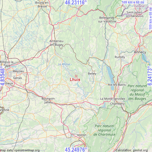
Lhuis GPS coordinates[2]
45° 44' 33.432" North, 5° 32' 18.96" East
| Map corner | latitude | longitude |
|---|---|---|
| Upper-left | 46.23116°, | 4.83548° |
| Center: | 45.74262°, | 5.5386° |
| Lower-right: | 45.24976°, | 6.24173° |
| Map W x H: | 109.1×109.1 km | = 67.8×67.8mi |
| max Lat: | 51.07786° ⇑70.2% North |
| Lhuis: | 45.74262° |
| min Lat: | ⇓29.8% South 41.3874° |
| min Long | Lhuis | max Long |
| -5.08615° | 5.5386° | 9.52242° |
| W 83.2%⇐ | ⇒16.8% E |
Elevation
Elevation of Lhuis is 526 m = 1726 ft, and this is 332.3 m = 1090 ft above average elevation for this country.
| Max E: |
2333 m = 7654 ft | 6.4% |
| Lhuis | 526 m 1726 ft | |
| Avg. | 193.7 m = 635 ft | |
Min E: |
-1 m = -3 ft | 93.6% |
See also: France elevation on elevation.city.
Geographical zone
Lhuis is located in North temperate zone (between Tropic of Cancer and the Arctic Circle). Distance of this North polar circle is 2315.1 km =1438.5 mi to North.| Distance of | km | miles | from Lhuis |
|---|---|---|---|
| North Pole | 4921 | 3057.8 | to North |
| Arctic Circle | 2315.1 | 1438.5 | to North |
| Tropic Cancer | 2480.2 | 1541.1 | to South |
| Equator | 5086.1 | 3160.4 | to South |


Nearby cities:
15 places around Lhuis: (largest is in red/bold)
• Belley
11.7 km =7.3 mi,  80°
80°
• Bouvesse-Quirieu
11.1 km =6.9 mi,  300°
300°
• Brangues
5.5 km =3.4 mi,  185°
185°
• Brens
11.9 km =7.4 mi,  96°
96°
• Briord
8 km =5 mi,  307°
307°
• Creys-Mépieu
4.4 km =2.7 mi,  256°
256°
• Curtin
11.7 km =7.3 mi,  198°
198°
• Le Bouchage
7.9 km =4.9 mi, 189°
• Les Avenières
12 km =7.5 mi,  171°
171°
• Morestel
9.1 km =5.7 mi,  219°
219°
• Passins
10.4 km =6.5 mi,  234°
234°
• Saint-Benoît
6.6 km =4.1 mi,  143°
143°
• Saint-Victor-de-Morestel
5.6 km =3.5 mi,  212°
212°
• Serrières-de-Briord
10 km =6.2 mi,  315°
315°
• Thuellin
11.7 km =7.3 mi, 191°
Sources, notices
• [Note1] Compared only with cities in France existing in our database
• [Src1] Map data: © OpenStreetMap contributors (CC-BY-SA)
• [Src2] Other city data from geonames.org with taken over terms of usage.
• [Src3] Geographical zone / Annual Mean Temperature by Robert A. Rohde @ Wikipedia
