Rully geodata
Rully (Bourgogne-Franche-Comté) is a populated place; located in France in Europe/Paris (GMT+2) time zone. With population of 1,547 people, there are 6025 cities with bigger population in this country. Compared to other cities in France, 56.5% of cities are located further ↑North; 74.3% of cities are located further ←West and 70.6% of cities have lower elevation than Rully. Note1
Administrative division(s):
- Level 1: Bourgogne-Franche-Comté
- Level 2: Département de Saône-et-Loire
- Level 3: Arrondissement de Chalon-sur-Saône
- Level 4: Rully


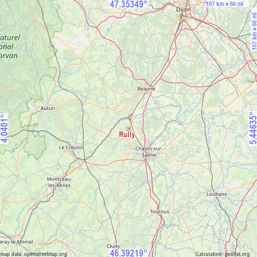
Rully GPS coordinates[2]
46° 52' 29.964" North, 4° 44' 35.592" East
| Map corner | latitude | longitude |
|---|---|---|
| Upper-left | 47.35349°, | 4.0401° |
| Center: | 46.87499°, | 4.74322° |
| Lower-right: | 46.39219°, | 5.44635° |
| Map W x H: | 106.9×106.9 km | = 66.4×66.4mi |
| max Lat: | 51.07786° ⇑56.5% North |
| Rully: | 46.87499° |
| min Lat: | ⇓43.5% South 41.3874° |
| min Long | Rully | max Long |
| -5.08615° | 4.74322° | 9.52242° |
| W 74.3%⇐ | ⇒25.7% E |
Elevation
Elevation of Rully is 222 m = 728 ft, and this is 28.3 m = 93 ft above average elevation for this country.
| Max E: |
2333 m = 7654 ft | 29.4% |
| Rully | 222 m 728 ft | |
| Avg. | 193.7 m = 635 ft | |
Min E: |
-1 m = -3 ft | 70.6% |
See also: France elevation on elevation.city.
Geographical zone
Rully is located in North temperate zone (between Tropic of Cancer and the Arctic Circle). Distance of this North polar circle is 2189.2 km =1360.3 mi to North.| Distance of | km | miles | from Rully |
|---|---|---|---|
| North Pole | 4795.1 | 2979.5 | to North |
| Arctic Circle | 2189.2 | 1360.3 | to North |
| Tropic Cancer | 2606.1 | 1619.4 | to South |
| Equator | 5212 | 3238.6 | to South |


Nearby cities:
15 places around Rully: (largest is in red/bold)
• Chagny
3.9 km =2.4 mi,  9°
9°
• Champforgeuil
9.3 km =5.8 mi,  132°
132°
• Chaudenay
5.7 km =3.5 mi,  35°
35°
• Corpeau
6.1 km =3.8 mi, 6°
• Demigny
9.2 km =5.7 mi,  48°
48°
• Dracy-le-Fort
8.7 km =5.4 mi,  170°
170°
• Farges-lès-Chalon
6.7 km =4.2 mi, 132°
• Fontaines
3.5 km =2.2 mi,  144°
144°
• Fragnes
8.8 km =5.5 mi,  119°
119°
• Lessard-le-National
7.3 km =4.5 mi,  97°
97°
• Mellecey
7.2 km =4.5 mi,  189°
189°
• Mercurey
4.3 km =2.7 mi,  206°
206°
• Saint-Léger-sur-Dheune
8.8 km =5.5 mi,  248°
248°
• Saint-Sernin-du-Plain
9.8 km =6.1 mi,  280°
280°
• Santenay
5.5 km =3.4 mi,  320°
320°
Sources, notices
• [Note1] Compared only with cities in France existing in our database
• [Src1] Map data: © OpenStreetMap contributors (CC-BY-SA)
• [Src2] Other city data from geonames.org with taken over terms of usage.
• [Src3] Geographical zone / Annual Mean Temperature by Robert A. Rohde @ Wikipedia
