Lesquin geodata
Lesquin (Hauts-de-France) is a populated place; located in France in Europe/Paris (GMT+2) time zone. With population of 6,424 people, there are 1540 cities with bigger population in this country. Compared to other cities in France, 97.9% of cities are located further ↓South; 59.5% of cities are located further ←West and 79.4% of cities have higher elevation than Lesquin. Note1
Administrative division(s):
- Level 1: Hauts-de-France
- Level 2: Nord
- Level 3: Arrondissement de Lille
- Level 4: Lesquin


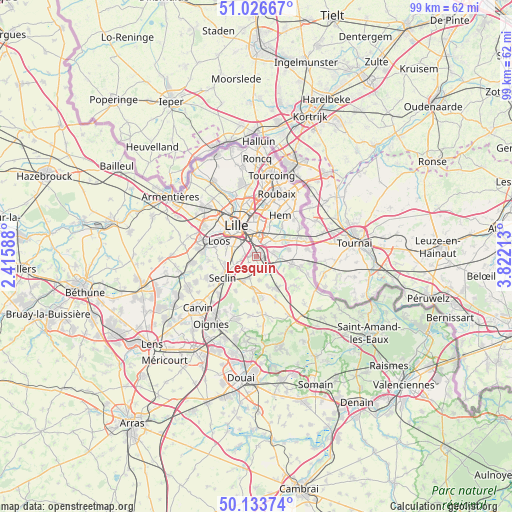
Lesquin GPS coordinates[2]
50° 34' 56.352" North, 3° 7' 8.4" East
| Map corner | latitude | longitude |
|---|---|---|
| Upper-left | 51.02667°, | 2.41588° |
| Center: | 50.58232°, | 3.119° |
| Lower-right: | 50.13374°, | 3.82213° |
| Map W x H: | 99.3×99.3 km | = 61.7×61.7mi |
| max Lat: | 51.07786° ⇑2.1% North |
| Lesquin: | 50.58232° |
| min Lat: | ⇓97.9% South 41.3874° |
| min Long | Lesquin | max Long |
| -5.08615° | 3.119° | 9.52242° |
| W 59.5%⇐ | ⇒40.5% E |
Elevation
Elevation of Lesquin is 56 m = 184 ft, and this is 137.7 m = 452 ft below average elevation for this country.
| Max E: |
2333 m = 7654 ft | 79.4% |
| Avg. | 193.7 m = 635 ft | |
| Lesquin | 56 m = 184 ft | |
Min E: |
-1 m = -3 ft | 20.6% |
See also: France elevation on elevation.city.
Geographical zone
Lesquin is located in North temperate zone (between Tropic of Cancer and the Arctic Circle). Distance of this North polar circle is 1776.9 km =1104.1 mi to North.| Distance of | km | miles | from Lesquin |
|---|---|---|---|
| North Pole | 4382.8 | 2723.3 | to North |
| Arctic Circle | 1776.9 | 1104.1 | to North |
| Tropic Cancer | 3018.3 | 1875.5 | to South |
| Equator | 5624.2 | 3494.7 | to South |


Nearby cities:
15 places around Lesquin: (largest is in red/bold)
• Anstaing
5.6 km =3.5 mi,  63°
63°
• Avelin
5.4 km =3.4 mi,  208°
208°
• Bouvines
4.9 km =3 mi,  94°
94°
• Ennevelin
4.6 km =2.9 mi,  170°
170°
• Faches-Thumesnil
3.7 km =2.3 mi,  271°
271°
• Fretin
3 km =1.9 mi,  155°
155°
• Lezennes
3.7 km =2.3 mi,  354°
354°
• Mons-en-Barœul
5.7 km =3.5 mi,  358°
358°
• Péronne-en-Mélantois
3.9 km =2.4 mi,  114°
114°
• Ronchin
2.7 km =1.7 mi,  312°
312°
• Sainghin-en-Mélantois
3.4 km =2.1 mi,  78°
78°
• Templemars
4.7 km =2.9 mi,  258°
258°
• Vendeville
2.9 km =1.8 mi, 258°
• Villeneuve-d'Ascq
5.1 km =3.2 mi,  41°
41°
• Wattignies
5.3 km =3.3 mi, 274°
Sources, notices
• [Note1] Compared only with cities in France existing in our database
• [Src1] Map data: © OpenStreetMap contributors (CC-BY-SA)
• [Src2] Other city data from geonames.org with taken over terms of usage.
• [Src3] Geographical zone / Annual Mean Temperature by Robert A. Rohde @ Wikipedia
