Ennevelin geodata
Ennevelin (Hauts-de-France) is a populated place; located in France in Europe/Paris (GMT+2) time zone. With population of 2,015 people, there are 4760 cities with bigger population in this country. Compared to other cities in France, 97.7% of cities are located further ↓South; 59.7% of cities are located further ←West and 88.6% of cities have higher elevation than Ennevelin. Note1
Administrative division(s):
- Level 1: Hauts-de-France
- Level 2: Nord
- Level 3: Arrondissement de Lille
- Level 4: Ennevelin


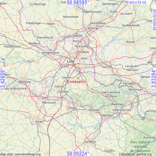
Ennevelin GPS coordinates[2]
50° 32' 28.356" North, 3° 7' 46.992" East
| Map corner | latitude | longitude |
|---|---|---|
| Upper-left | 50.98595°, | 2.42659° |
| Center: | 50.54121°, | 3.12972° |
| Lower-right: | 50.09224°, | 3.83284° |
| Map W x H: | 99.4×99.4 km | = 61.8×61.8mi |
| max Lat: | 51.07786° ⇑2.3% North |
| Ennevelin: | 50.54121° |
| min Lat: | ⇓97.7% South 41.3874° |
| min Long | Ennevelin | max Long |
| -5.08615° | 3.12972° | 9.52242° |
| W 59.7%⇐ | ⇒40.3% E |
Elevation
Elevation of Ennevelin is 33 m = 108 ft, and this is 160.7 m = 527 ft below average elevation for this country.
| Max E: |
2333 m = 7654 ft | 88.6% |
| Avg. | 193.7 m = 635 ft | |
| Ennevelin | 33 m = 108 ft | |
Min E: |
-1 m = -3 ft | 11.4% |
See also: France elevation on elevation.city.
Geographical zone
Ennevelin is located in North temperate zone (between Tropic of Cancer and the Arctic Circle). Distance of this North polar circle is 1781.5 km =1107 mi to North.| Distance of | km | miles | from Ennevelin |
|---|---|---|---|
| North Pole | 4387.4 | 2726.2 | to North |
| Arctic Circle | 1781.5 | 1107 | to North |
| Tropic Cancer | 3013.7 | 1872.6 | to South |
| Equator | 5619.7 | 3491.9 | to South |


Nearby cities:
15 places around Ennevelin: (largest is in red/bold)
• Attiches
5.2 km =3.2 mi,  246°
246°
• Avelin
3.4 km =2.1 mi,  267°
267°
• Bouvines
5.9 km =3.7 mi,  45°
45°
• Cappelle-en-Pévèle
4.5 km =2.8 mi,  139°
139°
• Fretin
1.9 km =1.2 mi,  15°
15°
• Genech
6.2 km =3.9 mi,  100°
100°
• Lesquin
4.6 km =2.9 mi,  350°
350°
• Louvil
4.9 km =3 mi,  67°
67°
• Mérignies
4.1 km =2.5 mi,  199°
199°
• Pont-à-Marcq
2.4 km =1.5 mi,  207°
207°
• Péronne-en-Mélantois
4.1 km =2.5 mi,  43°
43°
• Sainghin-en-Mélantois
5.8 km =3.6 mi,  26°
26°
• Templeuve-en-Pévèle
4 km =2.5 mi,  120°
120°
• Tourmignies
5 km =3.1 mi,  220°
220°
• Vendeville
5.4 km =3.4 mi,  317°
317°
Sources, notices
• [Note1] Compared only with cities in France existing in our database
• [Src1] Map data: © OpenStreetMap contributors (CC-BY-SA)
• [Src2] Other city data from geonames.org with taken over terms of usage.
• [Src3] Geographical zone / Annual Mean Temperature by Robert A. Rohde @ Wikipedia
