Fretin geodata
Fretin (Hauts-de-France) is a populated place; located in France in Europe/Paris (GMT+2) time zone. With population of 3,048 people, there are 3191 cities with bigger population in this country. Compared to other cities in France, 97.8% of cities are located further ↓South; 59.8% of cities are located further ←West and 89.1% of cities have higher elevation than Fretin. Note1
Administrative division(s):
- Level 1: Hauts-de-France
- Level 2: Nord
- Level 3: Arrondissement de Lille
- Level 4: Fretin


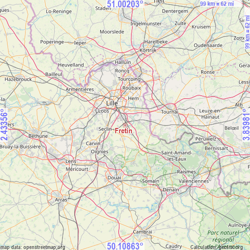
Fretin GPS coordinates[2]
50° 33' 26.82" North, 3° 8' 12.048" East
| Map corner | latitude | longitude |
|---|---|---|
| Upper-left | 51.00203°, | 2.43356° |
| Center: | 50.55745°, | 3.13668° |
| Lower-right: | 50.10863°, | 3.83981° |
| Map W x H: | 99.3×99.3 km | = 61.7×61.7mi |
| max Lat: | 51.07786° ⇑2.2% North |
| Fretin: | 50.55745° |
| min Lat: | ⇓97.8% South 41.3874° |
| min Long | Fretin | max Long |
| -5.08615° | 3.13668° | 9.52242° |
| W 59.8%⇐ | ⇒40.2% E |
Elevation
Elevation of Fretin is 32 m = 105 ft, and this is 161.7 m = 531 ft below average elevation for this country.
| Max E: |
2333 m = 7654 ft | 89.1% |
| Avg. | 193.7 m = 635 ft | |
| Fretin | 32 m = 105 ft | |
Min E: |
-1 m = -3 ft | 10.9% |
See also: France elevation on elevation.city.
Geographical zone
Fretin is located in North temperate zone (between Tropic of Cancer and the Arctic Circle). Distance of this North polar circle is 1779.7 km =1105.9 mi to North.| Distance of | km | miles | from Fretin |
|---|---|---|---|
| North Pole | 4385.6 | 2725.1 | to North |
| Arctic Circle | 1779.7 | 1105.9 | to North |
| Tropic Cancer | 3015.5 | 1873.7 | to South |
| Equator | 5621.5 | 3493 | to South |


Nearby cities:
15 places around Fretin: (largest is in red/bold)
• Avelin
4.3 km =2.7 mi,  242°
242°
• Bouvines
4.4 km =2.7 mi,  57°
57°
• Cappelle-en-Pévèle
5.8 km =3.6 mi,  155°
155°
• Cysoing
5.8 km =3.6 mi,  76°
76°
• Ennevelin
1.9 km =1.2 mi,  195°
195°
• Faches-Thumesnil
5.7 km =3.5 mi,  300°
300°
• Lesquin
3 km =1.9 mi,  335°
335°
• Louvil
4 km =2.5 mi,  89°
89°
• Mérignies
6 km =3.7 mi, 197°
• Pont-à-Marcq
4.2 km =2.6 mi, 201°
• Péronne-en-Mélantois
2.6 km =1.6 mi, 63°
• Ronchin
5.6 km =3.5 mi,  324°
324°
• Sainghin-en-Mélantois
4 km =2.5 mi,  31°
31°
• Templeuve-en-Pévèle
4.8 km =3 mi,  142°
142°
• Vendeville
4.6 km =2.9 mi, 297°
Sources, notices
• [Note1] Compared only with cities in France existing in our database
• [Src1] Map data: © OpenStreetMap contributors (CC-BY-SA)
• [Src2] Other city data from geonames.org with taken over terms of usage.
• [Src3] Geographical zone / Annual Mean Temperature by Robert A. Rohde @ Wikipedia
