Lespignan geodata
Lespignan (Occitanie) is a populated place; located in France in Europe/Paris (GMT+2) time zone. With population of 2,895 people, there are 3365 cities with bigger population in this country. Compared to other cities in France, 96.3% of cities are located further ↑North; 60.2% of cities are located further ←West and 89.1% of cities have higher elevation than Lespignan. Note1
Administrative division(s):
- Level 1: Occitanie
- Level 2: Département de l'Hérault
- Level 3: Arrondissement de Béziers
- Level 4: Lespignan


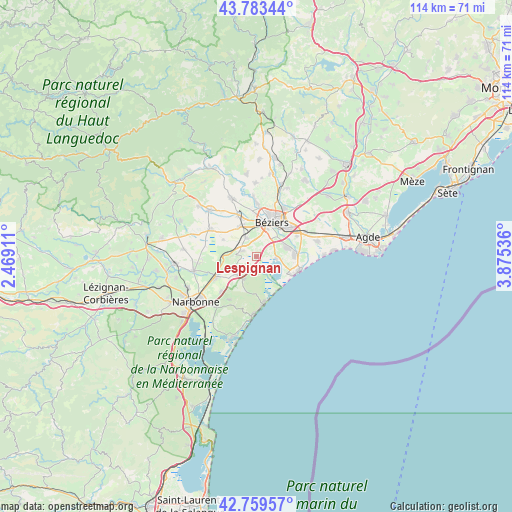
Lespignan GPS coordinates[2]
43° 16' 25.176" North, 3° 10' 20.064" East
| Map corner | latitude | longitude |
|---|---|---|
| Upper-left | 43.78344°, | 2.46911° |
| Center: | 43.27366°, | 3.17224° |
| Lower-right: | 42.75957°, | 3.87536° |
| Map W x H: | 113.8×113.8 km | = 70.7×70.7mi |
| max Lat: | 51.07786° ⇑96.3% North |
| Lespignan: | 43.27366° |
| min Lat: | ⇓3.7% South 41.3874° |
| min Long | Lespignan | max Long |
| -5.08615° | 3.17224° | 9.52242° |
| W 60.2%⇐ | ⇒39.8% E |
Elevation
Elevation of Lespignan is 32 m = 105 ft, and this is 161.7 m = 531 ft below average elevation for this country.
| Max E: |
2333 m = 7654 ft | 89.1% |
| Avg. | 193.7 m = 635 ft | |
| Lespignan | 32 m = 105 ft | |
Min E: |
-1 m = -3 ft | 10.9% |
See also: France elevation on elevation.city.
Geographical zone
Lespignan is located in North temperate zone (between Tropic of Cancer and the Arctic Circle). Distance of this Northern Tropic circle is 2205.7 km =1370.6 mi to South.| Distance of | km | miles | from Lespignan |
|---|---|---|---|
| North Pole | 5195.5 | 3228.3 | to North |
| Arctic Circle | 2589.6 | 1609.1 | to North |
| Tropic Cancer | 2205.7 | 1370.6 | to South |
| Equator | 4811.6 | 2989.8 | to South |


Nearby cities:
15 places around Lespignan: (largest is in red/bold)
• Armissan
11.3 km =7 mi,  212°
212°
• Béziers
8.2 km =5.1 mi,  24°
24°
• Colombiers
5.2 km =3.2 mi,  329°
329°
• Coursan
10.3 km =6.4 mi,  244°
244°
• Fleury
5.5 km =3.4 mi, 210°
• Maraussan
10.7 km =6.6 mi,  353°
353°
• Maureilhan
9.6 km =6 mi, 332°
• Montady
7.8 km =4.8 mi, 332°
• Nissan-lez-Enserune
4.1 km =2.5 mi,  295°
295°
• Sauvian
7.4 km =4.6 mi,  73°
73°
• Sérignan
8.5 km =5.3 mi,  86°
86°
• Valras-Plage
10 km =6.2 mi,  106°
106°
• Vendres
4.2 km =2.6 mi,  95°
95°
• Villeneuve-lès-Béziers
9.9 km =6.2 mi,  62°
62°
• Vinassan
11 km =6.8 mi,  225°
225°
Sources, notices
• [Note1] Compared only with cities in France existing in our database
• [Src1] Map data: © OpenStreetMap contributors (CC-BY-SA)
• [Src2] Other city data from geonames.org with taken over terms of usage.
• [Src3] Geographical zone / Annual Mean Temperature by Robert A. Rohde @ Wikipedia
