Fleury geodata
Fleury (Occitanie) is a populated place; located in France in Europe/Paris (GMT+2) time zone. With population of 2,713 people, there are 3605 cities with bigger population in this country. Compared to other cities in France, 96.8% of cities are located further ↑North; 59.8% of cities are located further ←West and 91.2% of cities have higher elevation than Fleury. Note1
Administrative division(s):
- Level 1: Occitanie
- Level 2: Département de l'Aude
- Level 3: Arrondissement de Narbonne
- Level 4: Fleury


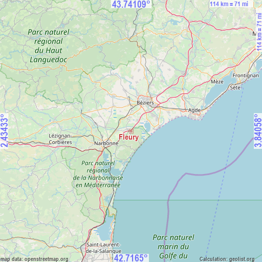
Fleury GPS coordinates[2]
43° 13' 51.42" North, 3° 8' 14.82" East
| Map corner | latitude | longitude |
|---|---|---|
| Upper-left | 43.74109°, | 2.43433° |
| Center: | 43.23095°, | 3.13745° |
| Lower-right: | 42.7165°, | 3.84058° |
| Map W x H: | 113.9×113.9 km | = 70.8×70.8mi |
| max Lat: | 51.07786° ⇑96.8% North |
| Fleury: | 43.23095° |
| min Lat: | ⇓3.2% South 41.3874° |
| min Long | Fleury | max Long |
| -5.08615° | 3.13745° | 9.52242° |
| W 59.8%⇐ | ⇒40.2% E |
Elevation
Elevation of Fleury is 27 m = 89 ft, and this is 166.7 m = 547 ft below average elevation for this country.
| Max E: |
2333 m = 7654 ft | 91.2% |
| Avg. | 193.7 m = 635 ft | |
| Fleury | 27 m = 89 ft | |
Min E: |
-1 m = -3 ft | 8.8% |
See also: France elevation on elevation.city.
Geographical zone
Fleury is located in North temperate zone (between Tropic of Cancer and the Arctic Circle). Distance of this Northern Tropic circle is 2200.9 km =1367.6 mi to South.| Distance of | km | miles | from Fleury |
|---|---|---|---|
| North Pole | 5200.2 | 3231.3 | to North |
| Arctic Circle | 2594.3 | 1612 | to North |
| Tropic Cancer | 2200.9 | 1367.6 | to South |
| Equator | 4806.8 | 2986.8 | to South |


Nearby cities:
15 places around Fleury: (largest is in red/bold)
• Armissan
5.8 km =3.6 mi,  214°
214°
• Béziers
13.7 km =8.5 mi,  26°
26°
• Capestang
13.1 km =8.1 mi,  325°
325°
• Colombiers
9.3 km =5.8 mi,  1°
1°
• Coursan
6.5 km =4 mi,  272°
272°
• Lespignan
5.5 km =3.4 mi, 30°
• Maureilhan
13.3 km =8.3 mi,  352°
352°
• Montady
11.7 km =7.3 mi,  356°
356°
• Narbonne
12.2 km =7.6 mi,  244°
244°
• Nissan-lez-Enserune
6.6 km =4.1 mi, 352°
• Sauvian
12.1 km =7.5 mi,  55°
55°
• Sérignan
12.5 km =7.8 mi, 64°
• Valras-Plage
12.5 km =7.8 mi,  81°
81°
• Vendres
8.2 km =5.1 mi, 58°
• Vinassan
5.9 km =3.7 mi, 239°
Sources, notices
• [Note1] Compared only with cities in France existing in our database
• [Src1] Map data: © OpenStreetMap contributors (CC-BY-SA)
• [Src2] Other city data from geonames.org with taken over terms of usage.
• [Src3] Geographical zone / Annual Mean Temperature by Robert A. Rohde @ Wikipedia
