Béziers geodata
Béziers (Occitanie) is a seat of a third-order administrative division; located in France in Europe/Paris (GMT+2) time zone. With population of 74,081 people, there are 64 cities with bigger population in this country. Compared to other cities in France, 95% of cities are located further ↑North; 60.8% of cities are located further ←West and 75.4% of cities have higher elevation than Béziers. Note1
Administrative division(s):
- Level 1: Occitanie
- Level 2: Département de l'Hérault
- Level 3: Arrondissement de Béziers
- Level 4: Béziers


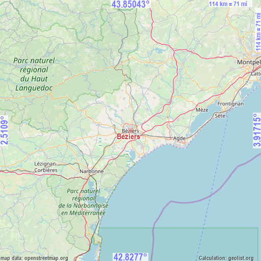
Béziers GPS coordinates[2]
43° 20' 28.392" North, 3° 12' 50.472" East
| Map corner | latitude | longitude |
|---|---|---|
| Upper-left | 43.85043°, | 2.5109° |
| Center: | 43.34122°, | 3.21402° |
| Lower-right: | 42.8277°, | 3.91715° |
| Map W x H: | 113.7×113.7 km | = 70.6×70.6mi |
| max Lat: | 51.07786° ⇑95% North |
| Béziers: | 43.34122° |
| min Lat: | ⇓5% South 41.3874° |
| min Long | Béziers | max Long |
| -5.08615° | 3.21402° | 9.52242° |
| W 60.8%⇐ | ⇒39.2% E |
Elevation
Elevation of Béziers is 66 m = 217 ft, and this is 127.7 m = 419 ft below average elevation for this country.
| Max E: |
2333 m = 7654 ft | 75.4% |
| Avg. | 193.7 m = 635 ft | |
| Béziers | 66 m = 217 ft | |
Min E: |
-1 m = -3 ft | 24.6% |
See also: Béziers elevation on elevation.city.
Geographical zone
Béziers is located in North temperate zone (between Tropic of Cancer and the Arctic Circle). Distance of this Northern Tropic circle is 2213.2 km =1375.2 mi to South.| Distance of | km | miles | from Béziers |
|---|---|---|---|
| North Pole | 5188 | 3223.7 | to North |
| Arctic Circle | 2582.1 | 1604.4 | to North |
| Tropic Cancer | 2213.2 | 1375.2 | to South |
| Equator | 4819.1 | 2994.4 | to South |


Nearby cities:
15 places around Béziers: (largest is in red/bold)
• Bassan
8.4 km =5.2 mi,  22°
22°
• Boujan-sur-Libron
4.2 km =2.6 mi,  40°
40°
• Cers
7.6 km =4.7 mi,  105°
105°
• Colombiers
6.7 km =4.2 mi,  243°
243°
• Corneilhan
6.7 km =4.2 mi,  344°
344°
• Lespignan
8.2 km =5.1 mi,  204°
204°
• Lieuran-lès-Béziers
8.8 km =5.5 mi,  12°
12°
• Lignan-sur-Orb
6 km =3.7 mi,  322°
322°
• Maraussan
5.6 km =3.5 mi,  303°
303°
• Maureilhan
7.9 km =4.9 mi,  277°
277°
• Montady
7 km =4.3 mi,  265°
265°
• Sauvian
6.5 km =4 mi,  145°
145°
• Sérignan
8.6 km =5.3 mi,  143°
143°
• Vendres
8 km =5 mi,  174°
174°
• Villeneuve-lès-Béziers
6.1 km =3.8 mi,  118°
118°
Sources, notices
• [Note1] Compared only with cities in France existing in our database
• [Src1] Map data: © OpenStreetMap contributors (CC-BY-SA)
• [Src2] Other city data from geonames.org with taken over terms of usage.
• [Src3] Geographical zone / Annual Mean Temperature by Robert A. Rohde @ Wikipedia
