Lescheraines geodata
Lescheraines (Auvergne-Rhône-Alpes) is a populated place; located in France in Europe/Paris (GMT+2) time zone. With population of 599 people, there are 13333 cities with bigger population in this country. Compared to other cities in France, 70.7% of cities are located further ↑North; 88.3% of cities are located further ←West and 95.8% of cities have lower elevation than Lescheraines. Note1
Administrative division(s):
- Level 1: Auvergne-Rhône-Alpes
- Level 2: Savoie
- Level 3: Arrondissement de Chambéry
- Level 4: Lescheraines


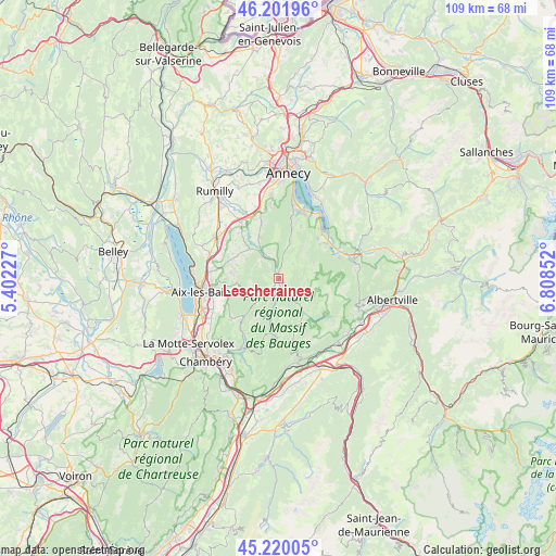
Lescheraines GPS coordinates[2]
45° 42' 47.376" North, 6° 6' 19.404" East
| Map corner | latitude | longitude |
|---|---|---|
| Upper-left | 46.20196°, | 5.40227° |
| Center: | 45.71316°, | 6.10539° |
| Lower-right: | 45.22005°, | 6.80852° |
| Map W x H: | 109.2×109.2 km | = 67.9×67.9mi |
| max Lat: | 51.07786° ⇑70.7% North |
| Lescheraines: | 45.71316° |
| min Lat: | ⇓29.3% South 41.3874° |
| min Long | Lescheraines | max Long |
| -5.08615° | 6.10539° | 9.52242° |
| W 88.3%⇐ | ⇒11.7% E |
Elevation
Elevation of Lescheraines is 629 m = 2064 ft, and this is 435.3 m = 1428 ft above average elevation for this country.
| Max E: |
2333 m = 7654 ft | 4.2% |
| Lescheraines | 629 m 2064 ft | |
| Avg. | 193.7 m = 635 ft | |
Min E: |
-1 m = -3 ft | 95.8% |
See also: France elevation on elevation.city.
Geographical zone
Lescheraines is located in North temperate zone (between Tropic of Cancer and the Arctic Circle). Distance of this North polar circle is 2318.3 km =1440.5 mi to North.| Distance of | km | miles | from Lescheraines |
|---|---|---|---|
| North Pole | 4924.2 | 3059.8 | to North |
| Arctic Circle | 2318.3 | 1440.5 | to North |
| Tropic Cancer | 2476.9 | 1539.1 | to South |
| Equator | 5082.8 | 3158.3 | to South |


Nearby cities:
15 places around Lescheraines: (largest is in red/bold)
• Alby-sur-Chéran
13.4 km =8.3 mi,  329°
329°
• Chainaz-les-Frasses
10.8 km =6.7 mi,  308°
308°
• Cusy
8.4 km =5.2 mi, 314°
• Doussard
11.6 km =7.2 mi,  53°
53°
• Gruffy
9.2 km =5.7 mi,  335°
335°
• Héry-sur-Alby
11.8 km =7.3 mi,  321°
321°
• Lathuile
11 km =6.8 mi,  44°
44°
• Le Châtelard
3.9 km =2.4 mi,  141°
141°
• Montcel
9.6 km =6 mi,  277°
277°
• Mûres
11.6 km =7.2 mi, 333°
• Pugny-Chatenod
12.3 km =7.6 mi,  262°
262°
• Saint-Offenge-dessous
8.3 km =5.2 mi,  286°
286°
• Saint-Ours
10.3 km =6.4 mi,  298°
298°
• Trévignin
11.7 km =7.3 mi,  266°
266°
• Viuz-la-Chiésaz
11.4 km =7.1 mi, 344°
Sources, notices
• [Note1] Compared only with cities in France existing in our database
• [Src1] Map data: © OpenStreetMap contributors (CC-BY-SA)
• [Src2] Other city data from geonames.org with taken over terms of usage.
• [Src3] Geographical zone / Annual Mean Temperature by Robert A. Rohde @ Wikipedia
