Le Châtelard geodata
Le Châtelard (Auvergne-Rhône-Alpes) is a populated place; located in France in Europe/Paris (GMT+2) time zone. With population of 645 people, there are 12593 cities with bigger population in this country. Compared to other cities in France, 71.1% of cities are located further ↑North; 88.7% of cities are located further ←West and 99.1% of cities have lower elevation than Le Châtelard. Note1
Administrative division(s):
- Level 1: Auvergne-Rhône-Alpes
- Level 2: Savoie
- Level 3: Arrondissement de Chambéry
- Level 4: Le Châtelard


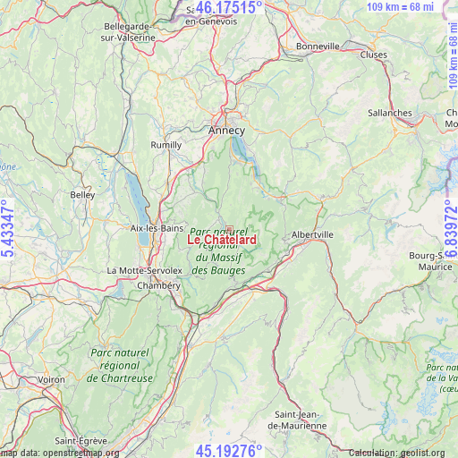
Le Châtelard GPS coordinates[2]
45° 41' 9.996" North, 6° 8' 11.76" East
| Map corner | latitude | longitude |
|---|---|---|
| Upper-left | 46.17515°, | 5.43347° |
| Center: | 45.68611°, | 6.1366° |
| Lower-right: | 45.19276°, | 6.83972° |
| Map W x H: | 109.2×109.2 km | = 67.9×67.9mi |
| max Lat: | 51.07786° ⇑71.1% North |
| Le Châtelard: | 45.68611° |
| min Lat: | ⇓28.9% South 41.3874° |
| min Long | Le Châtelard | max Long |
| -5.08615° | 6.1366° | 9.52242° |
| W 88.7%⇐ | ⇒11.3% E |
Elevation
Elevation of Le Châtelard is 997 m = 3271 ft, and this is 803.3 m = 2635 ft above average elevation for this country.
| Max E: |
2333 m = 7654 ft | 0.90000000000001% |
| Le Châtelard | 997 m 3271 ft | |
| Avg. | 193.7 m = 635 ft | |
Min E: |
-1 m = -3 ft | 99.1% |
See also: France elevation on elevation.city.
Geographical zone
Le Châtelard is located in North temperate zone (between Tropic of Cancer and the Arctic Circle). Distance of this North polar circle is 2321.4 km =1442.5 mi to North.| Distance of | km | miles | from Le Châtelard |
|---|---|---|---|
| North Pole | 4927.2 | 3061.6 | to North |
| Arctic Circle | 2321.4 | 1442.5 | to North |
| Tropic Cancer | 2473.9 | 1537.2 | to South |
| Equator | 5079.8 | 3156.4 | to South |


Nearby cities:
15 places around Le Châtelard: (largest is in red/bold)
• Cusy
12.2 km =7.6 mi,  316°
316°
• Doussard
12.1 km =7.5 mi,  34°
34°
• Faverges
14 km =8.7 mi,  58°
58°
• Gruffy
13 km =8.1 mi,  331°
331°
• Grésy-sur-Isère
13.3 km =8.3 mi,  136°
136°
• Lathuile
12.1 km =7.5 mi, 25°
• Lescheraines
3.9 km =2.4 mi, 321°
• Montailleur
13.4 km =8.3 mi,  124°
124°
• Montcel
12.7 km =7.9 mi,  289°
289°
• Saint-Jean-de-la-Porte
14.4 km =8.9 mi,  182°
182°
• Saint-Offenge-dessous
11.7 km =7.3 mi,  297°
297°
• Saint-Ours
14 km =8.7 mi, 304°
• Saint-Vital
14.2 km =8.8 mi, 117°
• Seythenex
13.4 km =8.3 mi,  70°
70°
• Trévignin
14.3 km =8.9 mi,  278°
278°
Sources, notices
• [Note1] Compared only with cities in France existing in our database
• [Src1] Map data: © OpenStreetMap contributors (CC-BY-SA)
• [Src2] Other city data from geonames.org with taken over terms of usage.
• [Src3] Geographical zone / Annual Mean Temperature by Robert A. Rohde @ Wikipedia
