Contes geodata
Contes (Provence-Alpes-Côte d'Azur) is a populated place; located in France in Europe/Paris (GMT+2) time zone. With population of 6,864 people, there are 1442 cities with bigger population in this country. Compared to other cities in France, 89% of cities are located further ↑North; 96.7% of cities are located further ←West and 75.9% of cities have lower elevation than Contes. Note1
Administrative division(s):
- Level 1: Provence-Alpes-Côte d'Azur
- Level 2: Alpes-Maritimes
- Level 3: Arrondissement de Nice
- Level 4: Contes


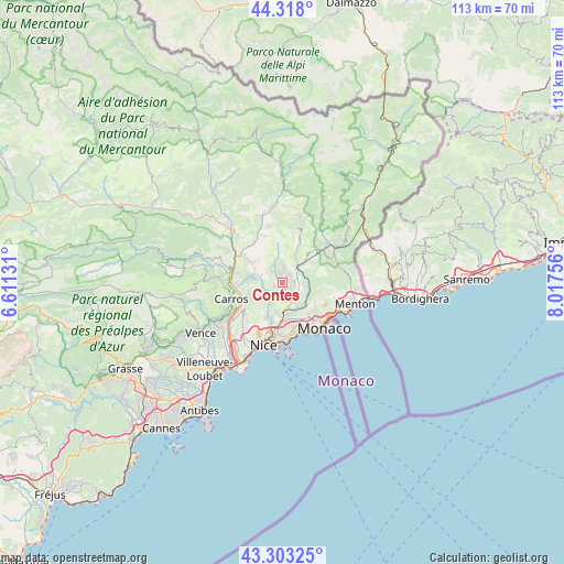
Contes GPS coordinates[2]
43° 48' 46.008" North, 7° 18' 51.984" East
| Map corner | latitude | longitude |
|---|---|---|
| Upper-left | 44.318°, | 6.61131° |
| Center: | 43.81278°, | 7.31444° |
| Lower-right: | 43.30325°, | 8.01756° |
| Map W x H: | 112.8×112.8 km | = 70.1×70.1mi |
| max Lat: | 51.07786° ⇑89% North |
| Contes: | 43.81278° |
| min Lat: | ⇓11% South 41.3874° |
| min Long | Contes | max Long |
| -5.08615° | 7.31444° | 9.52242° |
| W 96.7%⇐ | ⇒3.3% E |
Elevation
Elevation of Contes is 256 m = 840 ft, and this is 62.3 m = 204 ft above average elevation for this country.
| Max E: |
2333 m = 7654 ft | 24.1% |
| Contes | 256 m 840 ft | |
| Avg. | 193.7 m = 635 ft | |
Min E: |
-1 m = -3 ft | 75.9% |
See also: France elevation on elevation.city.
Geographical zone
Contes is located in North temperate zone (between Tropic of Cancer and the Arctic Circle). Distance of this Northern Tropic circle is 2265.6 km =1407.8 mi to South.| Distance of | km | miles | from Contes |
|---|---|---|---|
| North Pole | 5135.5 | 3191.1 | to North |
| Arctic Circle | 2529.6 | 1571.8 | to North |
| Tropic Cancer | 2265.6 | 1407.8 | to South |
| Equator | 4871.5 | 3027 | to South |


Nearby cities:
15 places around Contes: (largest is in red/bold)
• Aspremont
6.5 km =4 mi,  239°
239°
• Bendejun
3.1 km =1.9 mi,  328°
328°
• Berre-les-Alpes
2.3 km =1.4 mi,  30°
30°
• Blausasc
4.1 km =2.5 mi,  100°
100°
• Cantaron
5.6 km =3.5 mi,  177°
177°
• Castagniers
7.1 km =4.4 mi,  250°
250°
• Coaraze
5.9 km =3.7 mi,  344°
344°
• Drap
6.4 km =4 mi,  174°
174°
• Falicon
7.7 km =4.8 mi,  201°
201°
• La Trinité
8 km =5 mi, 180°
• L’Escarène
4.1 km =2.5 mi,  53°
53°
• Peille
7.1 km =4.4 mi, 98°
• Peillon
6.7 km =4.2 mi,  124°
124°
• Saint-Blaise
6.2 km =3.9 mi,  279°
279°
• Tourrette-Levens
4.3 km =2.7 mi,  226°
226°
Sources, notices
• [Note1] Compared only with cities in France existing in our database
• [Src1] Map data: © OpenStreetMap contributors (CC-BY-SA)
• [Src2] Other city data from geonames.org with taken over terms of usage.
• [Src3] Geographical zone / Annual Mean Temperature by Robert A. Rohde @ Wikipedia
