Bendejun geodata
Bendejun (Provence-Alpes-Côte d'Azur) is a populated place; located in France in Europe/Paris (GMT+2) time zone. With population of 876 people, there are 9846 cities with bigger population in this country. Compared to other cities in France, 88.7% of cities are located further ↑North; 96.4% of cities are located further ←West and 90.6% of cities have lower elevation than Bendejun. Note1
Administrative division(s):
- Level 1: Provence-Alpes-Côte d'Azur
- Level 2: Alpes-Maritimes
- Level 3: Arrondissement de Nice
- Level 4: Bendejun


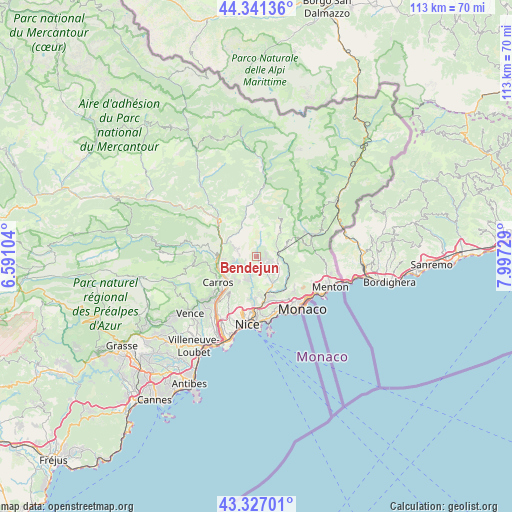
Bendejun GPS coordinates[2]
43° 50' 10.824" North, 7° 17' 38.976" East
| Map corner | latitude | longitude |
|---|---|---|
| Upper-left | 44.34136°, | 6.59104° |
| Center: | 43.83634°, | 7.29416° |
| Lower-right: | 43.32701°, | 7.99729° |
| Map W x H: | 112.8×112.8 km | = 70.1×70.1mi |
| max Lat: | 51.07786° ⇑88.7% North |
| Bendejun: | 43.83634° |
| min Lat: | ⇓11.3% South 41.3874° |
| min Long | Bendejun | max Long |
| -5.08615° | 7.29416° | 9.52242° |
| W 96.4%⇐ | ⇒3.6% E |
Elevation
Elevation of Bendejun is 440 m = 1444 ft, and this is 246.3 m = 808 ft above average elevation for this country.
| Max E: |
2333 m = 7654 ft | 9.4% |
| Bendejun | 440 m 1444 ft | |
| Avg. | 193.7 m = 635 ft | |
Min E: |
-1 m = -3 ft | 90.6% |
See also: France elevation on elevation.city.
Geographical zone
Bendejun is located in North temperate zone (between Tropic of Cancer and the Arctic Circle). Distance of this Northern Tropic circle is 2268.2 km =1409.4 mi to South.| Distance of | km | miles | from Bendejun |
|---|---|---|---|
| North Pole | 5132.9 | 3189.4 | to North |
| Arctic Circle | 2527 | 1570.2 | to North |
| Tropic Cancer | 2268.2 | 1409.4 | to South |
| Equator | 4874.1 | 3028.6 | to South |


Nearby cities:
15 places around Bendejun: (largest is in red/bold)
• Aspremont
7.1 km =4.4 mi,  214°
214°
• Berre-les-Alpes
2.9 km =1.8 mi,  103°
103°
• Blausasc
6.6 km =4.1 mi,  121°
121°
• Bonson
8.9 km =5.5 mi,  289°
289°
• Cantaron
8.5 km =5.3 mi,  167°
167°
• Castagniers
7.1 km =4.4 mi,  225°
225°
• Coaraze
3.1 km =1.9 mi,  0°
0°
• Contes
3.1 km =1.9 mi,  148°
148°
• La Roquette-sur-Var
7.7 km =4.8 mi,  263°
263°
• Levens
6.1 km =3.8 mi,  295°
295°
• Lucéram
7.4 km =4.6 mi,  45°
45°
• L’Escarène
4.9 km =3 mi,  91°
91°
• Saint-Blaise
4.8 km =3 mi,  250°
250°
• Saint-Martin-du-Var
8.5 km =5.3 mi, 256°
• Tourrette-Levens
5.7 km =3.5 mi,  194°
194°
Sources, notices
• [Note1] Compared only with cities in France existing in our database
• [Src1] Map data: © OpenStreetMap contributors (CC-BY-SA)
• [Src2] Other city data from geonames.org with taken over terms of usage.
• [Src3] Geographical zone / Annual Mean Temperature by Robert A. Rohde @ Wikipedia
