Lucéram geodata
Lucéram (Provence-Alpes-Côte d'Azur) is a populated place; located in France in Europe/Paris (GMT+2) time zone. With population of 1,080 people, there are 8260 cities with bigger population in this country. Compared to other cities in France, 88.2% of cities are located further ↑North; 97% of cities are located further ←West and 96.2% of cities have lower elevation than Lucéram. Note1
Administrative division(s):
- Level 1: Provence-Alpes-Côte d'Azur
- Level 2: Alpes-Maritimes
- Level 3: Arrondissement de Nice
- Level 4: Lucéram


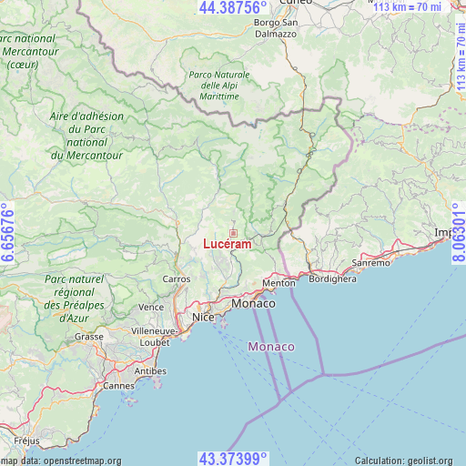
Lucéram GPS coordinates[2]
43° 52' 58.548" North, 7° 21' 35.568" East
| Map corner | latitude | longitude |
|---|---|---|
| Upper-left | 44.38756°, | 6.65676° |
| Center: | 43.88293°, | 7.35988° |
| Lower-right: | 43.37399°, | 8.06301° |
| Map W x H: | 112.7×112.7 km | = 70×70mi |
| max Lat: | 51.07786° ⇑88.2% North |
| Lucéram: | 43.88293° |
| min Lat: | ⇓11.8% South 41.3874° |
| min Long | Lucéram | max Long |
| -5.08615° | 7.35988° | 9.52242° |
| W 97%⇐ | ⇒3% E |
Elevation
Elevation of Lucéram is 656 m = 2152 ft, and this is 462.3 m = 1517 ft above average elevation for this country.
| Max E: |
2333 m = 7654 ft | 3.8% |
| Lucéram | 656 m 2152 ft | |
| Avg. | 193.7 m = 635 ft | |
Min E: |
-1 m = -3 ft | 96.2% |
See also: France elevation on elevation.city.
Geographical zone
Lucéram is located in North temperate zone (between Tropic of Cancer and the Arctic Circle). Distance of this Northern Tropic circle is 2273.4 km =1412.6 mi to South.| Distance of | km | miles | from Lucéram |
|---|---|---|---|
| North Pole | 5127.7 | 3186.2 | to North |
| Arctic Circle | 2521.8 | 1567 | to North |
| Tropic Cancer | 2273.4 | 1412.6 | to South |
| Equator | 4879.3 | 3031.9 | to South |


Nearby cities:
15 places around Lucéram: (largest is in red/bold)
• Bendejun
7.4 km =4.6 mi,  225°
225°
• Berre-les-Alpes
6.3 km =3.9 mi,  203°
203°
• Blausasc
8.6 km =5.3 mi,  177°
177°
• Coaraze
5.6 km =3.5 mi,  248°
248°
• Contes
8.6 km =5.3 mi,  205°
205°
• Gorbio
12.6 km =7.8 mi,  147°
147°
• Lantosque
10.9 km =6.8 mi,  339°
339°
• Levens
11.1 km =6.9 mi,  256°
256°
• L’Escarène
5.4 km =3.4 mi, 183°
• Peille
9.5 km =5.9 mi,  159°
159°
• Peillon
11.7 km =7.3 mi,  171°
171°
• Saint-Blaise
11.9 km =7.4 mi,  235°
235°
• Sainte-Agnès
12.3 km =7.6 mi,  138°
138°
• Sospel
7.1 km =4.4 mi,  94°
94°
• Utelle
9.8 km =6.1 mi,  292°
292°
Sources, notices
• [Note1] Compared only with cities in France existing in our database
• [Src1] Map data: © OpenStreetMap contributors (CC-BY-SA)
• [Src2] Other city data from geonames.org with taken over terms of usage.
• [Src3] Geographical zone / Annual Mean Temperature by Robert A. Rohde @ Wikipedia
