Les Bordes-sur-Arize geodata
Les Bordes-sur-Arize (Occitanie) is a populated place; located in France in Europe/Paris (GMT+2) time zone. With population of 535 people, there are 14511 cities with bigger population in this country. Compared to other cities in France, 97.9% of cities are located further ↑North; 64.7% of cities are located further →East and 77.3% of cities have lower elevation than Les Bordes-sur-Arize. Note1
Administrative division(s):
- Level 1: Occitanie
- Level 2: Département de l'Ariège
- Level 3: Arrondissement de Saint-Girons
- Level 4: Les Bordes-sur-Arize


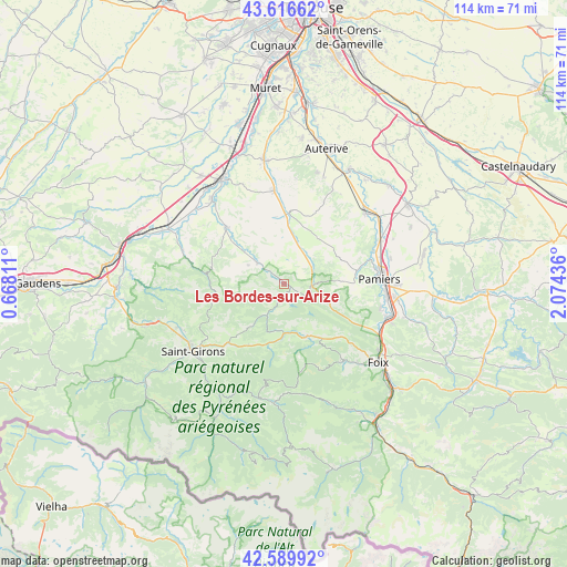
Les Bordes-sur-Arize GPS coordinates[2]
43° 6' 19.512" North, 1° 22' 16.464" East
| Map corner | latitude | longitude |
|---|---|---|
| Upper-left | 43.61662°, | 0.66811° |
| Center: | 43.10542°, | 1.37124° |
| Lower-right: | 42.58992°, | 2.07436° |
| Map W x H: | 114.2×114.2 km | = 71×71mi |
| max Lat: | 51.07786° ⇑97.9% North |
| Les Bordes-sur-Arize: | 43.10542° |
| min Lat: | ⇓2.1% South 41.3874° |
| min Long | Les Bordes-sur- | max Long |
| -5.08615° | 1.37124° | 9.52242° |
| W 35.3%⇐ | ⇒64.7% E |
Elevation
Elevation of Les Bordes-sur-Arize is 266 m = 873 ft, and this is 72.3 m = 237 ft above average elevation for this country.
| Max E: |
2333 m = 7654 ft | 22.7% |
| Les Bordes-sur-Arize | 266 m 873 ft | |
| Avg. | 193.7 m = 635 ft | |
Min E: |
-1 m = -3 ft | 77.3% |
See also: France elevation on elevation.city.
Geographical zone
Les Bordes-sur-Arize is located in North temperate zone (between Tropic of Cancer and the Arctic Circle). Distance of this Northern Tropic circle is 2187 km =1358.9 mi to South.| Distance of | km | miles | from Les Bordes-sur-Arize |
|---|---|---|---|
| North Pole | 5214.2 | 3240 | to North |
| Arctic Circle | 2608.3 | 1620.7 | to North |
| Tropic Cancer | 2187 | 1358.9 | to South |
| Equator | 4792.9 | 2978.2 | to South |


Nearby cities:
15 places around Les Bordes-sur-Arize: (largest is in red/bold)
• Artigat
6.6 km =4.1 mi,  57°
57°
• Bonnac
19.2 km =11.9 mi,  69°
69°
• Carla-Bayle
5.2 km =3.2 mi,  20°
20°
• Daumazan-sur-Arize
6.7 km =4.2 mi,  308°
308°
• Gaillac-Toulza
18.5 km =11.5 mi,  25°
25°
• La Bastide-de-Sérou
11.4 km =7.1 mi,  155°
155°
• Le Fossat
8.2 km =5.1 mi, 21°
• Lézat-sur-Lèze
19.2 km =11.9 mi,  354°
354°
• Montesquieu-Volvestre
16.2 km =10.1 mi, 314°
• Pamiers
19.5 km =12.1 mi,  86°
86°
• Rieux-de-Pelleport
20.1 km =12.5 mi,  105°
105°
• Rimont
14.2 km =8.8 mi,  210°
210°
• Saint-Ybars
14.7 km =9.1 mi,  4°
4°
• Sainte-Croix-Volvestre
16.9 km =10.5 mi,  280°
280°
• Serres-sur-Arget
19.2 km =11.9 mi,  142°
142°
Sources, notices
• [Note1] Compared only with cities in France existing in our database
• [Src1] Map data: © OpenStreetMap contributors (CC-BY-SA)
• [Src2] Other city data from geonames.org with taken over terms of usage.
• [Src3] Geographical zone / Annual Mean Temperature by Robert A. Rohde @ Wikipedia
