Le Plessis-Mériot geodata
Le Plessis-Mériot (Grand Est) is a populated place; located in France in Europe/Paris (GMT+2) time zone. With population of 501 people, there are 15224 cities with bigger population in this country. Compared to other cities in France, 68.6% of cities are located further ↓South; 63.6% of cities are located further ←West and 66.6% of cities have higher elevation than Le Plessis-Mériot. Note1
Administrative division(s):
- Level 1: Grand Est
- Level 2: Département de l'Aube
- Level 3: Arrondissement de Nogent-sur-Seine
- Level 4: Le Mériot


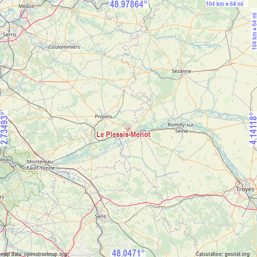
Le Plessis-Mériot GPS coordinates[2]
48° 30' 54.036" North, 3° 26' 16.98" East
| Map corner | latitude | longitude |
|---|---|---|
| Upper-left | 48.97864°, | 2.73493° |
| Center: | 48.51501°, | 3.43805° |
| Lower-right: | 48.0471°, | 4.14118° |
| Map W x H: | 103.6×103.6 km | = 64.4×64.4mi |
| max Lat: | 51.07786° ⇑31.4% North |
| Le Plessis-Mériot: | 48.51501° |
| min Lat: | ⇓68.6% South 41.3874° |
| min Long | Le Plessis-Mér | max Long |
| -5.08615° | 3.43805° | 9.52242° |
| W 63.6%⇐ | ⇒36.4% E |
Elevation
Elevation of Le Plessis-Mériot is 86 m = 282 ft, and this is 107.7 m = 353 ft below average elevation for this country.
| Max E: |
2333 m = 7654 ft | 66.6% |
| Avg. | 193.7 m = 635 ft | |
| Le Plessis-Mériot | 86 m = 282 ft | |
Min E: |
-1 m = -3 ft | 33.4% |
See also: France elevation on elevation.city.
Geographical zone
Le Plessis-Mériot is located in North temperate zone (between Tropic of Cancer and the Arctic Circle). Distance of this North polar circle is 2006.8 km =1247 mi to North.| Distance of | km | miles | from Le Plessis-Mériot |
|---|---|---|---|
| North Pole | 4612.7 | 2866.2 | to North |
| Arctic Circle | 2006.8 | 1247 | to North |
| Tropic Cancer | 2788.4 | 1732.6 | to South |
| Equator | 5394.4 | 3351.9 | to South |


Nearby cities:
15 places around Le Plessis-Mériot: (largest is in red/bold)
• Chalautre-la-Grande
3.4 km =2.1 mi,  28°
28°
• Chalautre-la-Petite
9.4 km =5.8 mi,  279°
279°
• Fontaine-Fourches
11.8 km =7.3 mi,  197°
197°
• Gouaix
11.2 km =7 mi,  252°
252°
• Hermé
7.6 km =4.7 mi,  243°
243°
• Léchelle
7.9 km =4.9 mi,  332°
332°
• Nogent-sur-Seine
5.3 km =3.3 mi,  116°
116°
• Pont-sur-Seine
11.7 km =7.3 mi,  88°
88°
• Provins
11.3 km =7 mi,  295°
295°
• Saint-Aubin
9.8 km =6.1 mi, 116°
• Saint-Brice
10.2 km =6.3 mi, 304°
• Soisy-Bouy
10.5 km =6.5 mi,  268°
268°
• Sourdun
6.8 km =4.2 mi,  290°
290°
• Traînel
11 km =6.8 mi,  175°
175°
• Villenauxe-la-Grande
11.2 km =7 mi,  47°
47°
Sources, notices
• [Note1] Compared only with cities in France existing in our database
• [Src1] Map data: © OpenStreetMap contributors (CC-BY-SA)
• [Src2] Other city data from geonames.org with taken over terms of usage.
• [Src3] Geographical zone / Annual Mean Temperature by Robert A. Rohde @ Wikipedia
