Fontaine-Fourches geodata
Fontaine-Fourches (Île-de-France) is a populated place; located in France in Europe/Paris (GMT+2) time zone. With population of 582 people, there are 13612 cities with bigger population in this country. Compared to other cities in France, 66.6% of cities are located further ↓South; 63.1% of cities are located further ←West and 68.7% of cities have higher elevation than Fontaine-Fourches. Note1
Administrative division(s):
- Level 1: Île-de-France
- Level 2: Seine-et-Marne
- Level 3: Arrondissement de Provins
- Level 4: Fontaine-Fourches


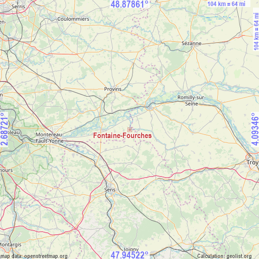
Fontaine-Fourches GPS coordinates[2]
48° 24' 50.616" North, 3° 23' 25.188" East
| Map corner | latitude | longitude |
|---|---|---|
| Upper-left | 48.87861°, | 2.68721° |
| Center: | 48.41406°, | 3.39033° |
| Lower-right: | 47.94522°, | 4.09346° |
| Map W x H: | 103.8×103.8 km | = 64.5×64.5mi |
| max Lat: | 51.07786° ⇑33.4% North |
| Fontaine-Fourches: | 48.41406° |
| min Lat: | ⇓66.6% South 41.3874° |
| min Long | Fontaine-Fourch | max Long |
| -5.08615° | 3.39033° | 9.52242° |
| W 63.1%⇐ | ⇒36.9% E |
Elevation
Elevation of Fontaine-Fourches is 81 m = 266 ft, and this is 112.7 m = 370 ft below average elevation for this country.
| Max E: |
2333 m = 7654 ft | 68.7% |
| Avg. | 193.7 m = 635 ft | |
| Fontaine-Fourches | 81 m = 266 ft | |
Min E: |
-1 m = -3 ft | 31.3% |
See also: France elevation on elevation.city.
Geographical zone
Fontaine-Fourches is located in North temperate zone (between Tropic of Cancer and the Arctic Circle). Distance of this North polar circle is 2018 km =1253.9 mi to North.| Distance of | km | miles | from Fontaine-Fourches |
|---|---|---|---|
| North Pole | 4623.9 | 2873.2 | to North |
| Arctic Circle | 2018 | 1253.9 | to North |
| Tropic Cancer | 2777.2 | 1725.7 | to South |
| Equator | 5383.1 | 3344.9 | to South |


Nearby cities:
15 places around Fontaine-Fourches: (largest is in red/bold)
• Bray-sur-Seine
11.2 km =7 mi,  269°
269°
• Chalmaison
12.8 km =8 mi,  306°
306°
• Everly
11.9 km =7.4 mi,  299°
299°
• Gouaix
10.7 km =6.6 mi,  317°
317°
• Hermé
8.5 km =5.3 mi,  337°
337°
• Le Plessis-Mériot
11.8 km =7.3 mi,  17°
17°
• Les Ormes-sur-Voulzie
13.1 km =8.1 mi,  294°
294°
• Mousseaux-lès-Bray
12 km =7.5 mi, 270°
• Nogent-sur-Seine
12.1 km =7.5 mi,  43°
43°
• Saint-Aubin
14.1 km =8.8 mi,  60°
60°
• Sergines
12.4 km =7.7 mi,  229°
229°
• Soisy-Bouy
12.9 km =8 mi,  327°
327°
• Sourdun
13.9 km =8.6 mi,  348°
348°
• Thorigny-sur-Oreuse
13.5 km =8.4 mi,  176°
176°
• Traînel
4.4 km =2.7 mi,  86°
86°
Sources, notices
• [Note1] Compared only with cities in France existing in our database
• [Src1] Map data: © OpenStreetMap contributors (CC-BY-SA)
• [Src2] Other city data from geonames.org with taken over terms of usage.
• [Src3] Geographical zone / Annual Mean Temperature by Robert A. Rohde @ Wikipedia
